IMAGES TAKEN NEAR TO
Kinthall Lane, TENBURY WELLS, WR15 8QR
Introduction
This page details the photographs taken nearby to Kinthall Lane, WR15 8QR by members of the Geograph project.
The Geograph project started in 2005 with the aim of publishing, organising and preserving representative images for every square kilometre of Great Britain, Ireland and the Isle of Man.

There are currently over 7.5m images from over14,400 individuals and you can help contribute to the project by visiting https://www.geograph.org.uk
Image Map (Loading...)


Getting Data...Please wait
Leaflet Map data © OpenStreetMap
Images are licensed for reuse under creativecommons.org/licenses/by-sa/2.0
Notes
- Clicking on the map will re-center to the selected point.
- The higher the marker number, the further away the image location is from the centre of the postcode.
Image Listing (9 Images Found)
Images are licensed for reuse under creativecommons.org/licenses/by-sa/2.0
Image
Details
Distance
1
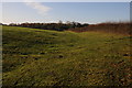
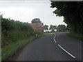
View to Kintol Plantation
Kintol Plantation can be seen beyond this field near Wolferlow. The county boundary between Herefordshire and Worcestershire follows the hedgerow on the right, Herefordshire is this side of the hedge.
Image: © Philip Halling
Taken: 6 Nov 2011
0.16 miles
2
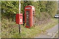
Telephone box, Broad Heath
Under notice of closure.
Image: © Richard Webb
Taken: 8 Oct 2017
0.21 miles
3
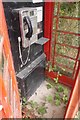
Telephone box, Broad Heath
Vegetation takes over, there were a couple of closure notices above the apparatus.
Image: © Richard Webb
Taken: 8 Oct 2017
0.21 miles
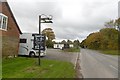
5
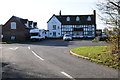
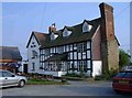
The Fox Inn
The Fox Inn near Hanley William.
Image: © Philip Halling
Taken: 6 Nov 2011
0.22 miles
8
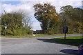
Road junction by the Fox Inn
A very likeable pub, right on the corner of Worcestershire - Herefordshire immediately south and east!
Image: © Richard Webb
Taken: 8 Oct 2017
0.23 miles
9
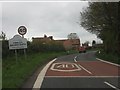
B4204 passes the Fox Inn
The high level road between Tenbury and Worcester passes through Broadheath.
Image: © Richard Webb
Taken: 19 Oct 2016
0.23 miles