IMAGES TAKEN NEAR TO
Romers Common, TENBURY WELLS, WR15 8PU
Introduction
This page details the photographs taken nearby to Romers Common, WR15 8PU by members of the Geograph project.
The Geograph project started in 2005 with the aim of publishing, organising and preserving representative images for every square kilometre of Great Britain, Ireland and the Isle of Man.

There are currently over 7.5m images from over14,400 individuals and you can help contribute to the project by visiting https://www.geograph.org.uk
Image Map (Loading...)


Getting Data...Please wait
Leaflet Map data © OpenStreetMap
Images are licensed for reuse under creativecommons.org/licenses/by-sa/2.0
Notes
- Clicking on the map will re-center to the selected point.
- The higher the marker number, the further away the image location is from the centre of the postcode.
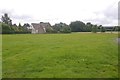
Image Listing (4 Images Found)
Images are licensed for reuse under creativecommons.org/licenses/by-sa/2.0
Image
Details
Distance
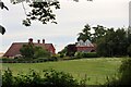
1
Romers Common
One of several roadside commons in the area.
Image: © Richard Webb
Taken: 4 Aug 2016
0.02 miles
2
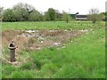
Romers Common
A shattered cast iron pump next to a large patch of cuckoo flower (Cardamine pratensis).
Image: © Richard Webb
Taken: 1 May 2010
0.02 miles
3
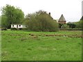
Romers Common
A long narrow common. View towards an oasthouse at Romers Farm.
Image: © Richard Webb
Taken: 1 May 2010
0.06 miles