IMAGES TAKEN NEAR TO
Eastham, TENBURY WELLS, WR15 8NN
Introduction
This page details the photographs taken nearby to WR15 8NN by members of the Geograph project.
The Geograph project started in 2005 with the aim of publishing, organising and preserving representative images for every square kilometre of Great Britain, Ireland and the Isle of Man.

There are currently over 7.5m images from over14,400 individuals and you can help contribute to the project by visiting https://www.geograph.org.uk
Image Map
Images are licensed for reuse under creativecommons.org/licenses/by-sa/2.0
Notes
- Clicking on the map will re-center to the selected point.
- The higher the marker number, the further away the image location is from the centre of the postcode.
Image Listing (5 Images Found)
Images are licensed for reuse under creativecommons.org/licenses/by-sa/2.0
Image
Details
Distance
1
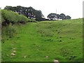
Bonfire Hill
A track once used this slope, now just grassland.
Image: © Richard Webb
Taken: 10 Aug 2010
0.11 miles
2
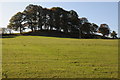
Trees on a knoll
Trees on a knoll in farmland near Eastham.
Image: © Philip Halling
Taken: 6 Nov 2011
0.16 miles
3
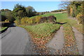
Country road at Eastham
Field entrance off a country road at Eastham.
Image: © Philip Halling
Taken: 6 Nov 2011
0.18 miles
4
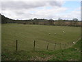
Grazing by the River
The trees at the edge of this field are following the source of the River Teme.
Image: © Michael Patterson
Taken: 12 Apr 2006
0.20 miles
5

Pasture by River Teme
Fields near Boat House Farm
Image: © P Gaskell
Taken: Unknown
0.21 miles