IMAGES TAKEN NEAR TO
Rhyse Lane, TENBURY WELLS, WR15 8NH
Introduction
This page details the photographs taken nearby to Rhyse Lane, WR15 8NH by members of the Geograph project.
The Geograph project started in 2005 with the aim of publishing, organising and preserving representative images for every square kilometre of Great Britain, Ireland and the Isle of Man.

There are currently over 7.5m images from over14,400 individuals and you can help contribute to the project by visiting https://www.geograph.org.uk
Image Map
Images are licensed for reuse under creativecommons.org/licenses/by-sa/2.0
Notes
- Clicking on the map will re-center to the selected point.
- The higher the marker number, the further away the image location is from the centre of the postcode.
Image Listing (5 Images Found)
Images are licensed for reuse under creativecommons.org/licenses/by-sa/2.0
Image
Details
Distance

2
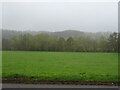
Flood Plain Field
Given the proximity of the River Teme, behind the trees, I would expect this land to be flooded from time to time. As the puddle demonstrates.
Image: © Michael Patterson
Taken: 12 Apr 2006
0.13 miles
4
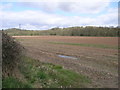
Teme flood plain
Stubble field opposite The Peacock.
Image: © Richard Webb
Taken: 15 Feb 2014
0.19 miles