IMAGES TAKEN NEAR TO
Knighton-on-Teme, TENBURY WELLS, WR15 8LT
Introduction
This page details the photographs taken nearby to WR15 8LT by members of the Geograph project.
The Geograph project started in 2005 with the aim of publishing, organising and preserving representative images for every square kilometre of Great Britain, Ireland and the Isle of Man.

There are currently over 7.5m images from over14,400 individuals and you can help contribute to the project by visiting https://www.geograph.org.uk
Image Map (Loading...)


Getting Data...Please wait
Leaflet Map data © OpenStreetMap
Images are licensed for reuse under creativecommons.org/licenses/by-sa/2.0
Notes
- Clicking on the map will re-center to the selected point.
- The higher the marker number, the further away the image location is from the centre of the postcode.
Image Listing (5 Images Found)
Images are licensed for reuse under creativecommons.org/licenses/by-sa/2.0
Image
Details
Distance
1
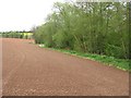
Cultivated field
The colour was quite striking, most arable land here was under winter crops and green. A narrow woodland runs along a watercourse beside the field.
Image: © Richard Webb
Taken: 2 May 2010
0.13 miles
2
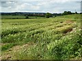
Farmland near Field Farm
A barley field near Field Farm, north of Newnham Bridge.
Image: © Philip Halling
Taken: 14 Jun 2017
0.15 miles
3
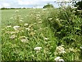
Cow parsley
Cow parsley in flower in the roadside verge near Newnham Bridge.
Image: © Philip Halling
Taken: 14 Jun 2017
0.20 miles
4
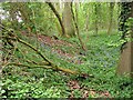
Bluebell wood
A narrow strip of deciduous woodland with some flowering bluebells.
Image: © Richard Webb
Taken: 2 May 2010
0.21 miles
5
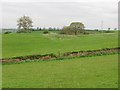
Undulating grassland, Knighton on Teme
The ground starts to slope steeply to the Teme or its tributary brooks here. Power lines are bound for Ludlow.
Image: © Richard Webb
Taken: 2 May 2010
0.21 miles