IMAGES TAKEN NEAR TO
Boraston Lane, TENBURY WELLS, WR15 8LD
Introduction
This page details the photographs taken nearby to Boraston Lane, WR15 8LD by members of the Geograph project.
The Geograph project started in 2005 with the aim of publishing, organising and preserving representative images for every square kilometre of Great Britain, Ireland and the Isle of Man.

There are currently over 7.5m images from over14,400 individuals and you can help contribute to the project by visiting https://www.geograph.org.uk
Image Map (Loading...)


Getting Data...Please wait
Leaflet Map data © OpenStreetMap
Images are licensed for reuse under creativecommons.org/licenses/by-sa/2.0
Notes
- Clicking on the map will re-center to the selected point.
- The higher the marker number, the further away the image location is from the centre of the postcode.
Image Listing (109 Images Found)
Images are licensed for reuse under creativecommons.org/licenses/by-sa/2.0
Image
Details
Distance
1
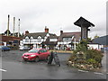
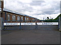
The Rose and Crown, Burford, Shropshire
Image: © Roger Cornfoot
Taken: 24 Oct 2009
0.03 miles

4
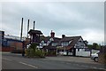
The Rose & Crown, Burford
Known locally as the Rosie I believe. Now surrounded by Kerry Ingredients large plant.
Image: © Jeremy Bolwell
Taken: 14 Aug 2012
0.05 miles
7

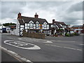
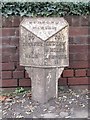
Old Milepost by the A456, Stanbrook House, Burford parish
Cast iron post by the A456, in parish of BURFORD (SOUTH SHROPSHIRE District), by Stanbrook House, Southeast of Boraston Lane, by the road. Erected by the Tenbury turnpike trust in the 19th century.
Inscription reads:-
: TO / TENBURY / ¼ MILE : : BURFORD / PARISH : : TO / LUDLOW / 9 MILES / LEMSTER / 11 :
Grade II listed.
List Entry Number: 1383424 https://historicengland.org.uk/listing/the-list/list-entry/1383424
Milestone Society National ID: SA_TBLD00
Image: © Robert Walker
Taken: Unknown
0.07 miles
8
Old Milepost by the A456, Stanbrook House, Burford parish
Cast iron post by the A456, in parish of BURFORD (SOUTH SHROPSHIRE District), by Stanbrook House, East of Boraston Lane, by the road. Erected by the Tenbury turnpike trust in the 19th century.
: TO / TENBURY / ¼ MILE : : BURFORD / PARISH : : TO / LUDLOW / 9 MILES / LEMSTER / 11 :
Grade II listed.
List Entry Number: 1383424 https://historicengland.org.uk/listing/the-list/list-entry/1383424
Milestone Society National ID: SA_TBLD00
Image: © John Haynes
Taken: Unknown
0.07 miles
9
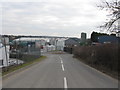
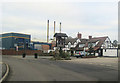
Tenbury Wells - Industrial Estate On Clee Hill Road
Image: © Peter Whatley
Taken: 9 Mar 2010
0.09 miles
10
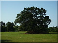
Tenbury Wells Castle and St. Mary's Church (Tenbury Wells)
Two important features in the town that would have worked out well, except the castle was defunct early and only a motte with two oak trees on it exist by today. The bell tower of St. Mary's church can be seen in the distance on the left, and that survived well.
Image: © Fabian Musto
Taken: 25 Jul 2019
0.09 miles