IMAGES TAKEN NEAR TO
Frith Common, TENBURY WELLS, WR15 8JY
Introduction
This page details the photographs taken nearby to Frith Common, WR15 8JY by members of the Geograph project.
The Geograph project started in 2005 with the aim of publishing, organising and preserving representative images for every square kilometre of Great Britain, Ireland and the Isle of Man.

There are currently over 7.5m images from over14,400 individuals and you can help contribute to the project by visiting https://www.geograph.org.uk
Image Map
Images are licensed for reuse under creativecommons.org/licenses/by-sa/2.0
Notes
- Clicking on the map will re-center to the selected point.
- The higher the marker number, the further away the image location is from the centre of the postcode.
Image Listing (2 Images Found)
Images are licensed for reuse under creativecommons.org/licenses/by-sa/2.0
Image
Details
Distance
1
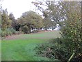
Spoil heap, Hunt House
Relic of the Wyre Forest coalfield which was in production near Mamble until 1950.
Image: © Richard Webb
Taken: 24 Oct 2014
0.20 miles
2
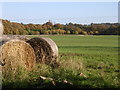
Bales and woods
Looking East into Hunthouse Wood. The land falls away steeply to the valley of Dumbleton Dingle, a Nature Reserve. Dumbleton Brook drains South from the watershed of Clows Top into the River Teme.
Image: © Richard Greenwood
Taken: 18 Nov 2006
0.23 miles