IMAGES TAKEN NEAR TO
Frith Common, TENBURY WELLS, WR15 8JX
Introduction
This page details the photographs taken nearby to Frith Common, WR15 8JX by members of the Geograph project.
The Geograph project started in 2005 with the aim of publishing, organising and preserving representative images for every square kilometre of Great Britain, Ireland and the Isle of Man.

There are currently over 7.5m images from over14,400 individuals and you can help contribute to the project by visiting https://www.geograph.org.uk
Image Map (Loading...)


Getting Data...Please wait
Leaflet Map data © OpenStreetMap
Images are licensed for reuse under creativecommons.org/licenses/by-sa/2.0
Notes
- Clicking on the map will re-center to the selected point.
- The higher the marker number, the further away the image location is from the centre of the postcode.
Image Listing (6 Images Found)
Images are licensed for reuse under creativecommons.org/licenses/by-sa/2.0
Image
Details
Distance
1
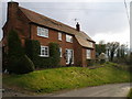
Frith Common
Weather clearing from the west.
Image: © Richard Webb
Taken: 24 Oct 2014
0.03 miles
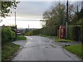
2
Dog walking at Frith Common
Taking to the road.
Image: © Jonathan Billinger
Taken: 31 Oct 2013
0.13 miles
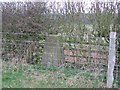
3

Old Boundary Markers near Frith Common
on the east side of a minor road heading north from Frith Common. On the boundary of Mamble and Lindridge parishes.
In front is a Parish Boundary Marker. The west face is unreadable but the south face is inscribed L, L. (Lindridge parish). The L is thought to represent Liberty, an area in which rights reserved to the king had been devolved into private hands.
Milestone Society National ID: WO_MAMLIN01pb
Behind is a Municipal Boundary Marker. On the boundary of Mamble and Lindridge parishes. In raised lettering on the west face is R (Rock Rural District) and on the south face is T (Tenbury Rural District).
Milestone Society National ID: WO_MAMLIN02pb
Image: © J Atkinson
Taken: Unknown
0.15 miles
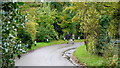
4
Frith Common
Footpaths diverge from this spot.
Image: © Jonathan Billinger
Taken: 31 Oct 2013
0.20 miles