IMAGES TAKEN NEAR TO
Lower Frith Common, TENBURY WELLS, WR15 8JU
Introduction
This page details the photographs taken nearby to Lower Frith Common, WR15 8JU by members of the Geograph project.
The Geograph project started in 2005 with the aim of publishing, organising and preserving representative images for every square kilometre of Great Britain, Ireland and the Isle of Man.

There are currently over 7.5m images from over14,400 individuals and you can help contribute to the project by visiting https://www.geograph.org.uk
Image Map (Loading...)


Getting Data...Please wait
Leaflet Map data © OpenStreetMap
Images are licensed for reuse under creativecommons.org/licenses/by-sa/2.0
Notes
- Clicking on the map will re-center to the selected point.
- The higher the marker number, the further away the image location is from the centre of the postcode.
Image Listing (4 Images Found)
Images are licensed for reuse under creativecommons.org/licenses/by-sa/2.0
Image
Details
Distance
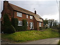
2
Frith Common
Weather clearing from the west.
Image: © Richard Webb
Taken: 24 Oct 2014
0.15 miles
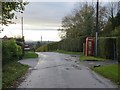
3
Approaching Frith Common
Approaching Frith Common from the west. The Image is interesting!
Image: © David Stowell
Taken: 7 Sep 2006
0.21 miles
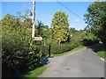
4
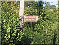
Roadsign near Frith Common
An unusual road sign pointing down a dead end lane from the road junction Image
Image: © David Stowell
Taken: 7 Sep 2006
0.21 miles