IMAGES TAKEN NEAR TO
Eardiston, TENBURY WELLS, WR15 8JR
Introduction
This page details the photographs taken nearby to WR15 8JR by members of the Geograph project.
The Geograph project started in 2005 with the aim of publishing, organising and preserving representative images for every square kilometre of Great Britain, Ireland and the Isle of Man.

There are currently over 7.5m images from over14,400 individuals and you can help contribute to the project by visiting https://www.geograph.org.uk
Image Map (Loading...)


Getting Data...Please wait
Leaflet Map data © OpenStreetMap
Images are licensed for reuse under creativecommons.org/licenses/by-sa/2.0
Notes
- Clicking on the map will re-center to the selected point.
- The higher the marker number, the further away the image location is from the centre of the postcode.
Image Listing (6 Images Found)
Images are licensed for reuse under creativecommons.org/licenses/by-sa/2.0
Image
Details
Distance
1
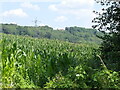
Fodder maize, Eardiston
Now often used as a source of biomass for anaerobic digesters. The power line serves Ludlow and Tenbury and would have connected to Stourport power station.
Image: © Richard Webb
Taken: 22 Jul 2021
0.07 miles
2
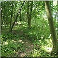
Link Hill
Wooded hills on the north side of the Teme at Eardiston.
Image: © Richard Webb
Taken: 22 Jul 2021
0.12 miles
4
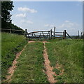
Footpath to Frith Common
Footpath to Frith Common from Dumbleton Lane.
Image: © Philip Halling
Taken: 28 Apr 2007
0.15 miles
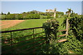
5

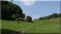
Little Switzerland
View down the Worcestershire bit of the Teme with Abberley School's clock tower on the left. Despite it's nickname it looks more like Burgundy to me. It was a very hot day.
Image: © Richard Webb
Taken: 22 Jul 2021
0.15 miles