IMAGES TAKEN NEAR TO
Lindridge, TENBURY WELLS, WR15 8JQ
Introduction
This page details the photographs taken nearby to WR15 8JQ by members of the Geograph project.
The Geograph project started in 2005 with the aim of publishing, organising and preserving representative images for every square kilometre of Great Britain, Ireland and the Isle of Man.

There are currently over 7.5m images from over14,400 individuals and you can help contribute to the project by visiting https://www.geograph.org.uk
Image Map (Loading...)


Getting Data...Please wait
Leaflet Map data © OpenStreetMap
Images are licensed for reuse under creativecommons.org/licenses/by-sa/2.0
Notes
- Clicking on the map will re-center to the selected point.
- The higher the marker number, the further away the image location is from the centre of the postcode.
Image Listing (28 Images Found)
Images are licensed for reuse under creativecommons.org/licenses/by-sa/2.0
Image
Details
Distance
1
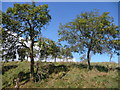
Damson orchard
This neglected orchard must have once provided a lot of damsons.
Image: © Richard Greenwood
Taken: 26 Sep 2014
0.07 miles
2
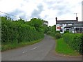
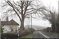
Minor road from A443 to Frith Common
The road passes the Nags Head on the right.
Image
Image: © P L Chadwick
Taken: 6 Jun 2010
0.09 miles
3
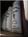
Hop sacks
Hops from Lambswick Farm supply three local breweries in Cleobury Mortimer, Ludlow and Bishop's Castle. Some are even exported to America. (information from farmer).
Image: © Richard Greenwood
Taken: 26 Sep 2014
0.10 miles
4
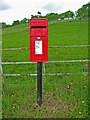
Rural postbox (Elizabeth II post mounted type) near A443
This postbox is on the corner of the minor road to Frith Common, where it joins the A443 road, and opposite the car park of the Nags Head. The postbox comes under the Tenbury Wells office, and is no. WR15 61.
Image: © P L Chadwick
Taken: 6 Jun 2010
0.11 miles
5
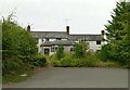
Cottage at entrance to Lambswick Farms
From A443
Image: © John Firth
Taken: 11 Apr 2013
0.11 miles
6
The former Nags Head, Lindridge
The makeover as an Indian restaurant http://www.geograph.org.uk/photo/1900907 has clearly failed to improve the fortune of this country pub. There are fewer boards over the windows than when Richard Webb passed this way the previous year http://www.geograph.org.uk/photo/4687002 , but the place still looks pretty derelict.
Image: © Alan Murray-Rust
Taken: 2 Sep 2016
0.12 miles
7

Nags Head
Since September 2009, this has been a balti indian restaurant and takeaway, under new ownership. Since it still advertises its beer garden, and has kept its traditional name, it would seem that it regards itself as a restaurant and pub. It has a special deal on Sunday buffets. It's good that a new use has been found for the premises, as so many rural pubs have been converted into private houses.
Image
Image: © P L Chadwick
Taken: 6 Jun 2010
0.12 miles
8
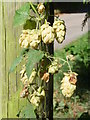
Hedgerow Hops, Little Lambswick Farm
The hops in the field behind the hedge have been harvested but I enjoyed the fragrance of these in the hedgerow.
Image: © Richard Greenwood
Taken: 26 Sep 2014
0.12 miles
9
The Nags Head
Closed pub beside the A443.
Image: © Richard Webb
Taken: 24 Oct 2014
0.13 miles
10

Pig ark, Lindridge
Across the road from what was the Nag's Head.
Image: © Richard Webb
Taken: 24 Oct 2014
0.13 miles