IMAGES TAKEN NEAR TO
TENBURY WELLS, WR15 8JL
Introduction
This page details the photographs taken nearby to WR15 8JL by members of the Geograph project.
The Geograph project started in 2005 with the aim of publishing, organising and preserving representative images for every square kilometre of Great Britain, Ireland and the Isle of Man.

There are currently over 7.5m images from over14,400 individuals and you can help contribute to the project by visiting https://www.geograph.org.uk
Image Map (Loading...)


Getting Data...Please wait
Leaflet Map data © OpenStreetMap
Images are licensed for reuse under creativecommons.org/licenses/by-sa/2.0
Notes
- Clicking on the map will re-center to the selected point.
- The higher the marker number, the further away the image location is from the centre of the postcode.
Image Listing (14 Images Found)
Images are licensed for reuse under creativecommons.org/licenses/by-sa/2.0
Image
Details
Distance
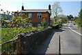
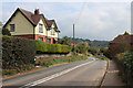
2
Eardiston road junction
Just east of Whitehouse Farm from A443
Image: © John Firth
Taken: 27 Dec 2011
0.05 miles
3
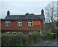
Brick-built cottage in Eardiston with an old advertisement
As it is a private house, purchasing Brooke Bond Tea here is no longer possible.
Image: © David Smith
Taken: 20 May 2013
0.05 miles
4
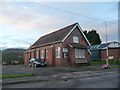
Lindridge Parish Hall, Eardiston, Worcs
A fine old village hall beside the main road.
Image: © Jeremy Bolwell
Taken: 28 Nov 2012
0.05 miles
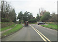
6
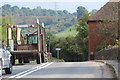
Hop picking tractor through Eardiston
Image: © Oast House Archive
Taken: 13 Sep 2014
0.11 miles
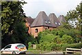
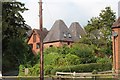
10
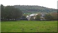
Moor Farm, Eardiston
The deep Teme valley in Worcestershire, AKA Little Switzerland.
Image: © Richard Webb
Taken: 8 Oct 2017
0.18 miles