IMAGES TAKEN NEAR TO
Woodston, TENBURY WELLS, WR15 8JG
Introduction
This page details the photographs taken nearby to WR15 8JG by members of the Geograph project.
The Geograph project started in 2005 with the aim of publishing, organising and preserving representative images for every square kilometre of Great Britain, Ireland and the Isle of Man.

There are currently over 7.5m images from over14,400 individuals and you can help contribute to the project by visiting https://www.geograph.org.uk
Image Map (Loading...)


Getting Data...Please wait
Leaflet Map data © OpenStreetMap
Images are licensed for reuse under creativecommons.org/licenses/by-sa/2.0
Notes
- Clicking on the map will re-center to the selected point.
- The higher the marker number, the further away the image location is from the centre of the postcode.
Image Listing (6 Images Found)
Images are licensed for reuse under creativecommons.org/licenses/by-sa/2.0
Image
Details
Distance
1
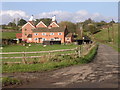
Farm with hop barns: Teme Valley
The lane to Woodston Manor.
Image: © Richard Greenwood
Taken: 12 Nov 2005
0.09 miles
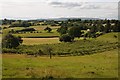
3
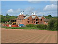
Orchard and Hop barns
This view is taken from the footpath along the ridge behind Lindridge church. The orchard is neglected and doesn't seem to bear fruit these days. The hop barns at
Woodston Farm Image are visible below.
Image: © Richard Greenwood
Taken: 26 Sep 2014
0.17 miles
4
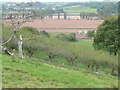
View over Woodstone Manor
View over Woodstone Manor in the Teme valley from a footpath just to the north of Lindridge church.
Image: © Philip Halling
Taken: 18 Jul 2015
0.18 miles
5
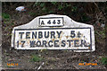
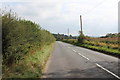
Old Milestone by the A443, Lindridge parish
Metal plates attached to concrete post by the A443, in parish of LINDRIDGE (MALVERN HILLS District), opposite drive to Woodston Farm, back of lay-by, on South side of road. Bradley post, erected by the County Council in the 20th century.
Inscription reads:-
: A443 : : TENBURY 5¼ . / 17 WORCESTER. : : C.C.W. :
Milestone Society National ID: WO_GWTN06.
Image: © J Higgins
Taken: 1 Apr 2007
0.22 miles