IMAGES TAKEN NEAR TO
Burford, TENBURY WELLS, WR15 8HS
Introduction
This page details the photographs taken nearby to WR15 8HS by members of the Geograph project.
The Geograph project started in 2005 with the aim of publishing, organising and preserving representative images for every square kilometre of Great Britain, Ireland and the Isle of Man.

There are currently over 7.5m images from over14,400 individuals and you can help contribute to the project by visiting https://www.geograph.org.uk
Image Map
Images are licensed for reuse under creativecommons.org/licenses/by-sa/2.0
Notes
- Clicking on the map will re-center to the selected point.
- The higher the marker number, the further away the image location is from the centre of the postcode.
Image Listing (11 Images Found)
Images are licensed for reuse under creativecommons.org/licenses/by-sa/2.0
Image
Details
Distance
1
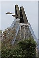
Former Railway Overbridge Near Burford Farm
Image: © Peter Whatley
Taken: 9 Mar 2010
0.10 miles
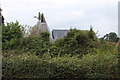
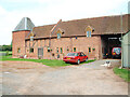
4
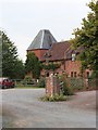
The Hop Barn, Burford Farm, Burford
Image: © Oast House Archive
Taken: 12 Sep 2014
0.17 miles
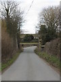
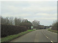
6
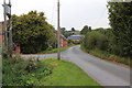
Junction for Burford House and gardens
From A456 westbound
Image: © John Firth
Taken: 27 Dec 2011
0.23 miles
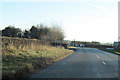
7
West junction for Burford House
From A456
Image: © John Firth
Taken: 27 Dec 2011
0.23 miles
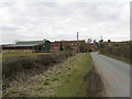
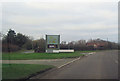
8
Entering Burford from the west on A456
Entrance to Burford House on right
Image: © John Firth
Taken: 22 Dec 2011
0.24 miles