IMAGES TAKEN NEAR TO
Burford, TENBURY WELLS, WR15 8HR
Introduction
This page details the photographs taken nearby to WR15 8HR by members of the Geograph project.
The Geograph project started in 2005 with the aim of publishing, organising and preserving representative images for every square kilometre of Great Britain, Ireland and the Isle of Man.

There are currently over 7.5m images from over14,400 individuals and you can help contribute to the project by visiting https://www.geograph.org.uk
Image Map (3 Images)


Leaflet Map data © OpenStreetMap
Images are licensed for reuse under creativecommons.org/licenses/by-sa/2.0
Notes
- Clicking on the map will re-center to the selected point.
- The higher the marker number, the further away the image location is from the centre of the postcode.
Image Listing (3 Images Found)
Images are licensed for reuse under creativecommons.org/licenses/by-sa/2.0
Image
Details
Distance
2
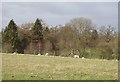
The Hole.
Roof of a secluded house just visible beyond the sheep. The aptly named property is in a steep reentrant falling towards the Letwyche.
Image: © Richard Webb
Taken: 1 Apr 2006
0.08 miles
3
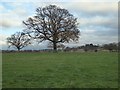
Farmland near Greete
Oak trees in a field near Greete.
Image: © Philip Halling
Taken: 29 Nov 2017
0.14 miles