IMAGES TAKEN NEAR TO
Burford, TENBURY WELLS, WR15 8HP
Introduction
This page details the photographs taken nearby to WR15 8HP by members of the Geograph project.
The Geograph project started in 2005 with the aim of publishing, organising and preserving representative images for every square kilometre of Great Britain, Ireland and the Isle of Man.

There are currently over 7.5m images from over14,400 individuals and you can help contribute to the project by visiting https://www.geograph.org.uk
Image Map (Loading...)


Getting Data...Please wait
Leaflet Map data © OpenStreetMap
Images are licensed for reuse under creativecommons.org/licenses/by-sa/2.0
Notes
- Clicking on the map will re-center to the selected point.
- The higher the marker number, the further away the image location is from the centre of the postcode.
Image Listing (8 Images Found)
Images are licensed for reuse under creativecommons.org/licenses/by-sa/2.0
Image
Details
Distance
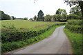
3
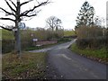
Lane Near Harpfields Farm
The farm is across the small valley, just into another gridsquare.
Image: © Peter Whatley
Taken: 9 Mar 2010
0.11 miles
5
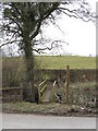
Footbridge Across Greet Brook
A modern and attractive structure, plus wooden sign with "Public Footpath" engraved in full.
Image: © Peter Whatley
Taken: 9 Mar 2010
0.16 miles
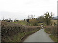
6
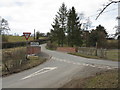
Welcome To Greete
The view from the triangular lane junction at Greet Brook bridge (note the spelling variation). Greete-ings?
Image: © Peter Whatley
Taken: 9 Mar 2010
0.17 miles
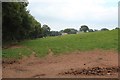
8
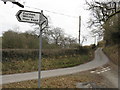
That's The Way To Tenbury!
Despite the signposts, the road ahead is the most direct route to Tenbury from Greete.
Image: © Peter Whatley
Taken: 9 Mar 2010
0.19 miles