IMAGES TAKEN NEAR TO
Burford, TENBURY WELLS, WR15 8HH
Introduction
This page details the photographs taken nearby to WR15 8HH by members of the Geograph project.
The Geograph project started in 2005 with the aim of publishing, organising and preserving representative images for every square kilometre of Great Britain, Ireland and the Isle of Man.

There are currently over 7.5m images from over14,400 individuals and you can help contribute to the project by visiting https://www.geograph.org.uk
Image Map (Loading...)


Getting Data...Please wait
Leaflet Map data © OpenStreetMap
Images are licensed for reuse under creativecommons.org/licenses/by-sa/2.0
Notes
- Clicking on the map will re-center to the selected point.
- The higher the marker number, the further away the image location is from the centre of the postcode.
Image Listing (13 Images Found)
Images are licensed for reuse under creativecommons.org/licenses/by-sa/2.0
Image
Details
Distance

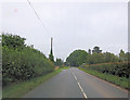
2
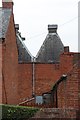
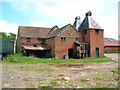
Oast House at Burford Mill, Burford
Image: © Oast House Archive
Taken: 12 Sep 2014
0.02 miles
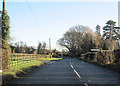
4
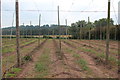
Hop fields at Burford Oaks
During the picking season. This field has been recently been cleared.
Image: © Oast House Archive
Taken: 12 Sep 2014
0.04 miles
5

Hop fields at Burford Oaks
During the picking season. This field has been partially harvested.
Image: © Oast House Archive
Taken: 12 Sep 2014
0.04 miles
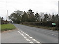
9
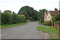
Junction for Bleathwood at Ledwich Bridge
From eastbound A456
Image: © John Firth
Taken: 22 Dec 2011
0.18 miles
10
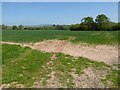
Arable field
Arable field near Little Hereford, Titterstone Clee Hill can be seen in the distance.
Image: © Philip Halling
Taken: 10 May 2017
0.22 miles