IMAGES TAKEN NEAR TO
Bromyard Road, TENBURY WELLS, WR15 8FG
Introduction
This page details the photographs taken nearby to Bromyard Road, WR15 8FG by members of the Geograph project.
The Geograph project started in 2005 with the aim of publishing, organising and preserving representative images for every square kilometre of Great Britain, Ireland and the Isle of Man.

There are currently over 7.5m images from over14,400 individuals and you can help contribute to the project by visiting https://www.geograph.org.uk
Image Map (Loading...)


Getting Data...Please wait
Leaflet Map data © OpenStreetMap
Images are licensed for reuse under creativecommons.org/licenses/by-sa/2.0
Notes
- Clicking on the map will re-center to the selected point.
- The higher the marker number, the further away the image location is from the centre of the postcode.
Image Listing (7 Images Found)
Images are licensed for reuse under creativecommons.org/licenses/by-sa/2.0
Image
Details
Distance
1
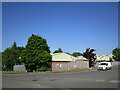
Industrial buildings, Tenbury Wells
Image: © Jonathan Thacker
Taken: 1 Jun 2023
0.07 miles
4
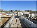
Waste reception, Tenbury
A very efficient and well run recycling facility.
Image: © Richard Webb
Taken: 19 Mar 2022
0.10 miles
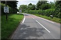
6

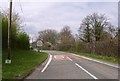
The Tenbury Wells to Bromyard road
The B4214 Tenbury Wells to Bromyard road pictured here just outside Tenbury.
Image: © Philip Halling
Taken: 18 Jul 2015
0.16 miles
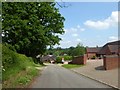
7
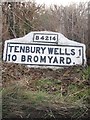
Old Milestone by the B4214, Bromyard Road, Splash Bridge
Metal plates attached to concrete post by the B4214, in parish of Tenbury (Malvern Hills District), Splash Bridge, by the road. Bradley post, erected by the Tenbury turnpike trust in the 20th century.
Inscription reads:-
B4214
TENBURY WELLS 1
10 BROMYARD.
Milestone Society National ID: WO_TBBY01
Image: © J Higgins
Taken: 1 Apr 2007
0.20 miles