IMAGES TAKEN NEAR TO
Orchard Court, TENBURY WELLS, WR15 8EZ
Introduction
This page details the photographs taken nearby to Orchard Court, WR15 8EZ by members of the Geograph project.
The Geograph project started in 2005 with the aim of publishing, organising and preserving representative images for every square kilometre of Great Britain, Ireland and the Isle of Man.

There are currently over 7.5m images from over14,400 individuals and you can help contribute to the project by visiting https://www.geograph.org.uk
Image Map (Loading...)


Getting Data...Please wait
Leaflet Map data © OpenStreetMap
Images are licensed for reuse under creativecommons.org/licenses/by-sa/2.0
Notes
- Clicking on the map will re-center to the selected point.
- The higher the marker number, the further away the image location is from the centre of the postcode.
Image Listing (213 Images Found)
Images are licensed for reuse under creativecommons.org/licenses/by-sa/2.0
Image
Details
Distance
1
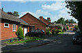
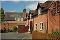
Orchard Court, Tenbury Wells
An estate of single-storey dwellings on the west side of the town.
Image: © Derek Harper
Taken: 15 Jul 2021
0.03 miles
2
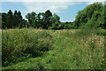
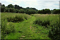
Teme flood plain
Grassland seen from the footpath shown in Image The trees border the River Teme.
Image: © Derek Harper
Taken: 15 Jul 2021
0.05 miles
3
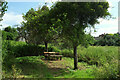
Picnic table near Tenbury Wells
By the footpath shown in Image
Image: © Derek Harper
Taken: 15 Jul 2021
0.05 miles
4
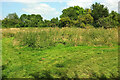
Footpath near Tenbury Wells
The grassy path seen in Image] becomes Tenbury footpath 740(B) for a few metres, but the numbered path heads off to the left as shown in the other direction at Image
Image: © Derek Harper
Taken: 15 Jul 2021
0.06 miles
5
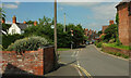
Berrington Road, Tenbury Wells
On the right is the last house of the terrace shown in Image The public footpath sign indicates Tenbury footpath 740(B), although you need to walk through Orchard Court to reach it.
Image: © Derek Harper
Taken: 15 Jul 2021
0.06 miles
6
Teme flood plain
Looking left from Image] along Tenbury footpath 740(B).
Image: © Derek Harper
Taken: 15 Jul 2021
0.07 miles
7

Willow near the Teme
Looking left from Image The tree has a certain resemblance to a shaggy dog. The trees behind are alongside the Teme.
Image: © Derek Harper
Taken: 15 Jul 2021
0.07 miles
8
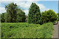
Trees near the Teme
On the right is footpath Tenbury 556(B).
Image: © Derek Harper
Taken: 15 Jul 2021
0.07 miles
9
Listed buildings, Tenbury Wells
On the right is a converted barn https://historicengland.org.uk/listing/the-list/list-entry/1179795?section=official-list-entry , now dwellings on College Court. Behind is 68, Berrington Road https://historicengland.org.uk/listing/the-list/list-entry/1349591?section=official-list-entry , originally C17.
Image: © Derek Harper
Taken: 15 Jul 2021
0.08 miles
10
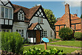
The Oak House, Tenbury Wells
The C17 house, on the left is listed https://historicengland.org.uk/listing/the-list/list-entry/1301807?section=official-list-entry and has a blue plaque outside. On the right is the end terrace of three which are also listed https://historicengland.org.uk/listing/the-list/list-entry/1082459?section=official-list-entry .
Image: © Derek Harper
Taken: 15 Jul 2021
0.08 miles