IMAGES TAKEN NEAR TO
Cornwall Gardens, TENBURY WELLS, WR15 8EU
Introduction
This page details the photographs taken nearby to Cornwall Gardens, WR15 8EU by members of the Geograph project.
The Geograph project started in 2005 with the aim of publishing, organising and preserving representative images for every square kilometre of Great Britain, Ireland and the Isle of Man.

There are currently over 7.5m images from over14,400 individuals and you can help contribute to the project by visiting https://www.geograph.org.uk
Image Map (Loading...)


Getting Data...Please wait
Leaflet Map data © OpenStreetMap
Images are licensed for reuse under creativecommons.org/licenses/by-sa/2.0
Notes
- Clicking on the map will re-center to the selected point.
- The higher the marker number, the further away the image location is from the centre of the postcode.
Image Listing (294 Images Found)
Images are licensed for reuse under creativecommons.org/licenses/by-sa/2.0
Image
Details
Distance
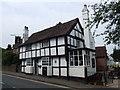
3
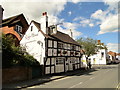
The Kings Head, Cross Street
Next door to Cornwall House, dating from 1600.
Image: © Philip Pankhurst
Taken: 10 Aug 2013
0.04 miles
4
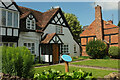
The Oak House, Tenbury Wells
The C17 house, on the left is listed https://historicengland.org.uk/listing/the-list/list-entry/1301807?section=official-list-entry and has a blue plaque outside. On the right is the end terrace of three which are also listed https://historicengland.org.uk/listing/the-list/list-entry/1082459?section=official-list-entry .
Image: © Derek Harper
Taken: 15 Jul 2021
0.04 miles
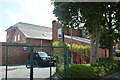
5
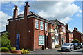
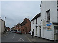
Police Station and former Court House - Berrington Road
Former drill hall dating from 1912 to a design by H Percy Smith of Worcester. Converted to police station and court in 1960. Court House has more recently been converted to Social Housing.
Image: © John M
Taken: 3 Aug 2014
0.04 miles
6
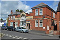
Former Court House and Police Station - Berrington Road
Former drill hall dating from 1912 to a design by H Percy Smith of Worcester. Converted to police station and court in 1960. Court House has more recently been converted to Social Housing.
Image: © John M
Taken: 3 Aug 2014
0.04 miles
9
Rear of Police Station - Berrington Road
Former drill hall dating from 1912 to a design by H Percy Smith of Worcester. Converted to police station and court in 1960. Court House has more recently been converted to Social Housing.
Image: © John M
Taken: 3 Aug 2014
0.05 miles
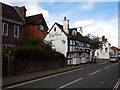
10
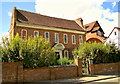
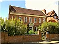
Cornwall House, Cross Street
Splendid late 17th century red brick house in Cross Street.
Image: © Philip Pankhurst
Taken: 10 Aug 2013
0.05 miles