IMAGES TAKEN NEAR TO
Juniper Way, MALVERN, WR14 4XG
Introduction
This page details the photographs taken nearby to Juniper Way, WR14 4XG by members of the Geograph project.
The Geograph project started in 2005 with the aim of publishing, organising and preserving representative images for every square kilometre of Great Britain, Ireland and the Isle of Man.

There are currently over 7.5m images from over14,400 individuals and you can help contribute to the project by visiting https://www.geograph.org.uk
Image Map
Images are licensed for reuse under creativecommons.org/licenses/by-sa/2.0
Notes
- Clicking on the map will re-center to the selected point.
- The higher the marker number, the further away the image location is from the centre of the postcode.
Image Listing (130 Images Found)
Images are licensed for reuse under creativecommons.org/licenses/by-sa/2.0
Image
Details
Distance
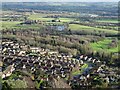
1
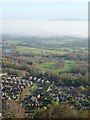
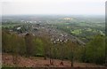
View from Upper Wyche
View over the Fruitlands estate and the fog bound Severn valley; Bredon Hill can be seen above the mist.
Image: © Philip Halling
Taken: 26 Nov 2020
0.02 miles
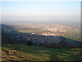
2
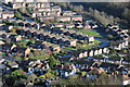
The Fruitlands Estate
The Fruitlands Estate viewed from a path on Perseverance Hill just below the summit ridge.
Image: © Philip Halling
Taken: 18 Dec 2011
0.02 miles
3
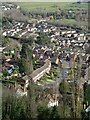
Fruitlands estate
The Fruitlands estate viewed from the Malvern Hills.
Image: © Philip Halling
Taken: 18 Feb 2021
0.03 miles
4
Fruitland estate
Fruitland estate, a 1970s housing development in Malvern.
Image: © Philip Halling
Taken: 2 Sep 2022
0.03 miles
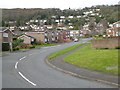
6
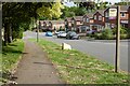
Fruitlands and Upper Wyche
Fruitlands, the road, on the Fruitlands Estate with the Upper Wyche in the Malvern Hills above in the background.
Image: © Philip Halling
Taken: 24 Mar 2020
0.05 miles
7
The Fruitlands estate
The Fruitlands estate viewed from the Malvern Hills.
Image: © Philip Halling
Taken: 16 Jan 2021
0.05 miles
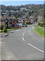
8
Fruitlands
Fruitlands housing estate as seen from Perseverance Hill. Most of the street names down there are names of fruit. The estate is bounded on the East by the Malvern to Ledbury railway which passes under the Malverns through a tunnel just below.
Image: © Trevor Rickard
Taken: 2 Feb 2007
0.05 miles
9
Fruitlands - Late '70s Housing Estate
Bounded by the Malvern to Hereford railway line and the back gardens of the houses on Peachfield Road, his housing estate crammed as many houses into the available space that the planning authority would allow. Viewed from the bridleway from the Wyche Cutting to the Holy Well.
Image: © Bob Embleton
Taken: 4 May 2008
0.06 miles
10
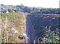
Railway Line Leaving Tunnel at Malvern Wells
View from above the entrance to the second railway tunnel between Colwall and Malvern Wells, opened 1926, looking North East. The edge of the Fruitlands housing estate can just be seen to the left of the cutting.
Image: © Angus McCulloch
Taken: 26 Sep 2008
0.06 miles