IMAGES TAKEN NEAR TO
Wells Road, MALVERN, WR14 4NZ
Introduction
This page details the photographs taken nearby to Wells Road, WR14 4NZ by members of the Geograph project.
The Geograph project started in 2005 with the aim of publishing, organising and preserving representative images for every square kilometre of Great Britain, Ireland and the Isle of Man.

There are currently over 7.5m images from over14,400 individuals and you can help contribute to the project by visiting https://www.geograph.org.uk
Image Map (Loading...)


Getting Data...Please wait
Leaflet Map data © OpenStreetMap
Images are licensed for reuse under creativecommons.org/licenses/by-sa/2.0
Notes
- Clicking on the map will re-center to the selected point.
- The higher the marker number, the further away the image location is from the centre of the postcode.
Image Listing (127 Images Found)
Images are licensed for reuse under creativecommons.org/licenses/by-sa/2.0
Image
Details
Distance
1

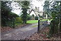
Lodge house to 'The Firs', Wells Road, Malvern Common
Image: © John Brightley
Taken: 6 Mar 2004
0.01 miles
2
Entrance to a lodge
Entrance to a lodge near The Firs on the edge of Malvern Common.
Image: © Philip Halling
Taken: 8 Jan 2018
0.01 miles
3
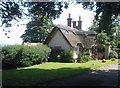
Cottage on the edge of Malvern Common
This attractive thatched cottage has rustic poles supporting the gable and a burrowing dog ornament on the lawn.
Image: © Trevor Rickard
Taken: 27 Jul 2008
0.01 miles
4
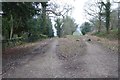
A choice of tracks on Malvern Common
A choice of tracks and paths on the north-west corner of Malvern Common.
Image: © Philip Halling
Taken: 8 Jan 2018
0.02 miles
5
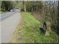
Milestone on the A449
Milestone on the A449 on Malvern Common, the plate has deteriorated since it was photographed by Bob Embleton in 2007 Image
Image: © Philip Halling
Taken: 26 Mar 2020
0.03 miles
6
Milestone on the A449
Milestone on the A449 on Malvern Common.
Image: © Philip Halling
Taken: 26 Mar 2020
0.03 miles
7
Milestone on Malvern Common
Detail of the milestone on the A449 Worcester to Ross road. Notice how it gives no distances to Ledbury or Ross.
Image: © Bob Embleton
Taken: 6 Apr 2007
0.04 miles
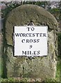
8
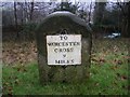
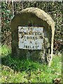
Old Milestone by the A449, Wells Road, Malvern parish
Metal plate attached to stone post by the A449, in parish of MALVERN (MALVERN HILLS District), The College; Wells Road, Malvern Wells Common (North end), on the verge under trees, on East side of road. Worcester Cross iron plate, erected by the Worcester turnpike trust in the 19th century.
Inscription reads:-
TO
WORCESTER
CROSS
9
MILES
Carved benchmark on top.
Grade II listed.
List Entry Number: 1391294 https://historicengland.org.uk/listing/the-list/list-entry/1391294
Milestone Society National ID: WO_WOLB09.
Image: © J Higgins
Taken: 1 Apr 2007
0.04 miles
9
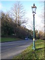
Gas Lamp, Malvern Common
Several roads are still lit by gas in the Malverns. Locally it is supposed that it was these lamps that inspired C.S.Lewis (who was at a boarding school here as a child) to include the gas lamp on the route into Narnia.
Image: © Bob Embleton
Taken: 21 Jan 2006
0.04 miles
10

A449 approaching Malvern Wells village sign
Image: © Roy Hughes
Taken: 24 Apr 2021
0.04 miles