IMAGES TAKEN NEAR TO
Holywell Road, MALVERN, WR14 4LF
Introduction
This page details the photographs taken nearby to Holywell Road, WR14 4LF by members of the Geograph project.
The Geograph project started in 2005 with the aim of publishing, organising and preserving representative images for every square kilometre of Great Britain, Ireland and the Isle of Man.

There are currently over 7.5m images from over14,400 individuals and you can help contribute to the project by visiting https://www.geograph.org.uk
Image Map
Images are licensed for reuse under creativecommons.org/licenses/by-sa/2.0
Notes
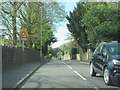
- Clicking on the map will re-center to the selected point.
- The higher the marker number, the further away the image location is from the centre of the postcode.
Image Listing (94 Images Found)
Images are licensed for reuse under creativecommons.org/licenses/by-sa/2.0
Image
Details
Distance
1
The Belvedere - Malvern Wells
The Belvedere is an early 19th century coach-house of painted brick with hipped slate roof and carriage doors on the east facing side of the Malverns.
Image: © Mick Lobb
Taken: 7 May 2010
0.03 miles
3
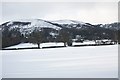
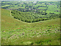
Malvern Wells in the snow
A view from the bridleway to Hanley Swan.
Looking over the fields of Brickbarns farm to the houses on the Wells Road and Holywell Road with the twin-peaked Pinnacle Hill behind.
Image: © Bob Embleton
Taken: 9 Jan 2010
0.05 miles
4
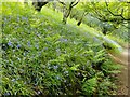
Pinnacle Hill bluebells
Bluebells on Pinnacle Hill in the Malvern Hills.
Image: © Oscar Taylor
Taken: 20 May 2023
0.07 miles
5
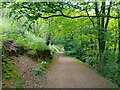
Pinnacle Hill path
One of the many criss-crossing bridleways and paths on Pinnacle Hill in the Malvern Hills.
Image: © Oscar Taylor
Taken: 20 May 2023
0.07 miles
6
View from the path below Pinnacle Hill
The town of Upton upon Severn can briefly be seen from this view (close-up Image). After I took this photograph, I had my lunch, and I always enjoy eating my lunch while looking at the breath-taking countryside views.
Image: © Fabian Musto
Taken: 15 Oct 2020
0.07 miles
7
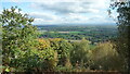
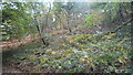
Wooded slopes below Pinnacle Hill
A splendid view which illustrates how quickly the land rises from the flat area east of the Malvern Hills. The village of Malvern Wells is tucked into the hillside and the Three Counties Showground can be seen in the distance.
Image: © Pauline E
Taken: 31 May 2008
0.07 miles
8
Woodland below Pinnacle Hill
There are many trees in the eastern slopes of Pinnacle Hill, part of the Malvern Hills range.
Image: © Fabian Musto
Taken: 15 Oct 2020
0.10 miles
9
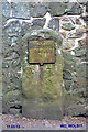
Old Milestone by the A449, Wells Road, Malvern Wells Parish
Metal plate attached to stone post by the A449, in parish of MALVERN WELLS (MALVERN HILLS District), North of The Abbey, in wall 10 yds South of "School" sign, on East side of road. Worcester Cross iron plate, erected by the Worcester turnpike trust in the 19th century.
Inscription reads:-
TO
WORCESTER
CROSS
11
MILES
Carved benchmark below plate.
Grade II listed. List Entry Number: 1391369
https://historicengland.org.uk/listing/the-list/list-entry/1391369
Milestone Society National ID: WO_WOLB11.
Image: © J Higgins
Taken: 1 Apr 2007
0.10 miles