IMAGES TAKEN NEAR TO
Upper Welland Road, MALVERN, WR14 4JU
Introduction
This page details the photographs taken nearby to Upper Welland Road, WR14 4JU by members of the Geograph project.
The Geograph project started in 2005 with the aim of publishing, organising and preserving representative images for every square kilometre of Great Britain, Ireland and the Isle of Man.

There are currently over 7.5m images from over14,400 individuals and you can help contribute to the project by visiting https://www.geograph.org.uk
Image Map
Images are licensed for reuse under creativecommons.org/licenses/by-sa/2.0
Notes
- Clicking on the map will re-center to the selected point.
- The higher the marker number, the further away the image location is from the centre of the postcode.
Image Listing (229 Images Found)
Images are licensed for reuse under creativecommons.org/licenses/by-sa/2.0
Image
Details
Distance
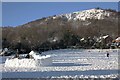
1
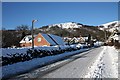
Upper Welland Road in the snow
The snow plough has managed to get through, but gritting has either not taken place or it is too cold to thaw.
In the background is Black Hill.
Image: © Bob Embleton
Taken: 7 Jan 2010
0.03 miles
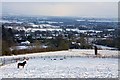
2
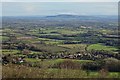
View over Upper Welland
View over Upper Welland and the Severn vale to Bredon Hill, viewed from Black Hill in the Malvern Hills.
Image: © Philip Halling
Taken: 15 Dec 2019
0.04 miles
3
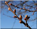
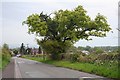
Oak Buds Swelling
At the end of March these buds are just about to burst into leaf.
Image: © Bob Embleton
Taken: 30 Mar 2008
0.04 miles
4
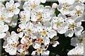
Hawthorn (Crataegus monogyna)
On May Day. One of the stipulations in the Welland Inclosure Act of 1951 was that all the inclosed land be properly fenced off within a given time. Hawthorns were planted in abundance.
Image: © Bob Embleton
Taken: 1 May 2007
0.05 miles
5
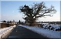
Old oak tree
On the Upper Welland road between Assarts Lane and Watery Lane. Getting a bit stunted and branches occasionally fall off, but it keeps going. Fresh with new pale green foliage.
Image: © Bob Embleton
Taken: 4 May 2008
0.05 miles
6
The Upper Welland Road
After the plough and gritters have got through the lower (less steep) portion of the road is quite usable.
Image: © Bob Embleton
Taken: 9 Jan 2010
0.05 miles
7
Snow covered fields
View from Kings Road down to Upper Welland and across the Severn plain to Bredon Hill.
Image: © Bob Embleton
Taken: 9 Jan 2010
0.06 miles
8
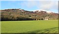
Mayall's Coppice in December
The first snow of the winter has fallen, but only settled on the hills.
Black Hill on the left and Pinnacle Hill on the right.
Image: © Bob Embleton
Taken: 16 Dec 2011
0.08 miles
9
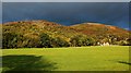
Mayall's Coppice in the early morning sun
The shadows are shortening as the sun climbs in the east.
Dark threatening clouds hang over Black Hill and Pinnacle Hill
Image: © Bob Embleton
Taken: 11 Oct 2011
0.08 miles
10
Igloo construction on Assarts playing field
A well constructed snow building on the playing field.
One parish councillor was heard to question whether planning permission had been given.
Behind is Black Hill with the exposed face of Berrington's Quarry.
Image: © Bob Embleton
Taken: 7 Jan 2010
0.09 miles