IMAGES TAKEN NEAR TO
Blackhill, MALVERN, WR14 4JT
Introduction
This page details the photographs taken nearby to Blackhill, WR14 4JT by members of the Geograph project.
The Geograph project started in 2005 with the aim of publishing, organising and preserving representative images for every square kilometre of Great Britain, Ireland and the Isle of Man.

There are currently over 7.5m images from over14,400 individuals and you can help contribute to the project by visiting https://www.geograph.org.uk
Image Map (Loading...)


Getting Data...Please wait
Leaflet Map data © OpenStreetMap
Images are licensed for reuse under creativecommons.org/licenses/by-sa/2.0
Notes
- Clicking on the map will re-center to the selected point.
- The higher the marker number, the further away the image location is from the centre of the postcode.
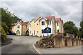
Image Listing (68 Images Found)
Images are licensed for reuse under creativecommons.org/licenses/by-sa/2.0
Image
Details
Distance
1
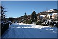
St Wulstans Drive in the snow
One of the larger houses (with triple garages) on the old St Wulstans hospital housing estate.
Most houses on the estate were built by Bovis, but those in Merebrook Close plus this one were built by Cala Homes.
Image: © Bob Embleton
Taken: 7 Jan 2010
0.02 miles
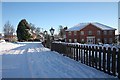
2
St Wulstans Drive in the snow
At the junction with St Peters Close.
Behind are Black Hill and Pinnacle Hill.
Image: © Bob Embleton
Taken: 7 Jan 2010
0.05 miles
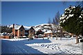
3
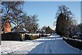
Houses on St Wulstans Drive
Detached houses built on the old orchards of the St Wulstans hospital site.
Behind is the quarried Black Hill on the left and Pinnacle Hill on the right.
Image: © Bob Embleton
Taken: 7 Jan 2010
0.07 miles
4
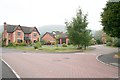
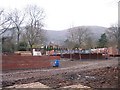
Bovis Homes on the St. Wulstan's Hospital Site
A few years ago this was all beautiful orchards at the western side of the old hospital site. Pinnacle Hill is in the background.
Image: © Bob Embleton
Taken: 3 May 2007
0.07 miles
5
In-Fill Upper Welland
A small paddock at the back of The Chase Rest Home has recently burst into life to provide yet more homes in this area.
Image: © Bob Embleton
Taken: 25 Dec 2005
0.07 miles
6
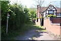
Bridleway around the back of St.Wulstans
Now a modern residential estate, but before that an american D-Day hospital and later a mental hospital. The bridleway to Brickbarns Farm was diverted around the war time camp and was never reinstated.
Image: © Bob Embleton
Taken: 1 May 2007
0.08 miles
7

Bridleway behind St.Wulstan's Hospital Site, Upper Welland
St Wulstan's was one of several war time hospitals built in preparation of the expected D-Day casualties. Later a mental hospital with workshops. On closure much of the site was converted into an estate of large houses. Despite their large gardens (back fence on the right of the picture) the owners appear to have created their compost heaps on the bridleway land.
Image: © Bob Embleton
Taken: 14 May 2006
0.10 miles
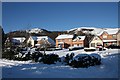
8
St Wulstans Drive in the snow
A few cars have got through, but most are waiting for the snow plough.
Black Hill on the right.
Image: © Bob Embleton
Taken: 7 Jan 2010
0.10 miles
9
St Wulstans Drive in the snow
Looking down towards the entrance to the nature reserve.
Image: © Bob Embleton
Taken: 7 Jan 2010
0.10 miles
10
The Chase care home, Upper Welland
At the heart of this complex is a large old private residence which has undergone several expansions over the last three decades.
Image: © Bob Embleton
Taken: 16 Jun 2014
0.11 miles