IMAGES TAKEN NEAR TO
The Purlieu, MALVERN, WR14 4DJ
Introduction
This page details the photographs taken nearby to The Purlieu, WR14 4DJ by members of the Geograph project.
The Geograph project started in 2005 with the aim of publishing, organising and preserving representative images for every square kilometre of Great Britain, Ireland and the Isle of Man.

There are currently over 7.5m images from over14,400 individuals and you can help contribute to the project by visiting https://www.geograph.org.uk
Image Map (Loading...)


Getting Data...Please wait
Leaflet Map data © OpenStreetMap
Images are licensed for reuse under creativecommons.org/licenses/by-sa/2.0
Notes
- Clicking on the map will re-center to the selected point.
- The higher the marker number, the further away the image location is from the centre of the postcode.
Image Listing (40 Images Found)
Images are licensed for reuse under creativecommons.org/licenses/by-sa/2.0
Image
Details
Distance
1
Purlieu View
The view from the junction of The Purlieu and the B4232.
Image: © Peter Whatley
Taken: 10 Jun 2008
0.12 miles
2
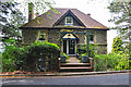
Upper Colwall : House on West Malvern Road
A house on West Malvern Road in Hereforedshire.
Image: © Lewis Clarke
Taken: 5 May 2014
0.15 miles
3
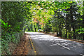
Herefordshire : West Malvern Road B4232
Looking along West Malvern Road as it heads through Herefordshire.
Image: © Lewis Clarke
Taken: 5 May 2014
0.15 miles
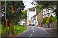
4
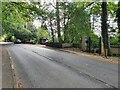
West Malvern Road, Malvern
Views along West Malvern Road, Malvern. The gatepost on the right hand side of road also has an Ordnance Survey bench mark.
Image
Image: © V1ncenze
Taken: 24 Sep 2021
0.17 miles
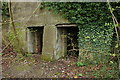
5

Ordnance Survey Bench Mark
This mark is located on a gatepost outside Purlieu House, West Malvern road, Malvern. These marks were used by Ordnance Survey for mapping purposes.
Image
Image: © V1ncenze
Taken: 24 Sep 2021
0.17 miles
6
The Royal Malvern Well - 2007 Well Dressing
The inscription reads: "This Fountain of Pure Water and Tank is the sole gift of W. H. Ryland of Bewdley to the inhabitants of this neighbourhood and the public 1870. WASTE NOT WANT NOT"
Image: © Bob Embleton
Taken: 29 Apr 2007
0.17 miles
7
Herefordshire : West Malvern Road B4232
Approaching houses overlooking the hillside on West Malvern Road.
Image: © Lewis Clarke
Taken: 5 May 2014
0.20 miles
8
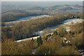
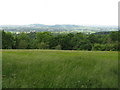
Wooded hills, Upper Colwall
View across wooded hills towards Mathon from the Malvern Hills above Upper Colwall.
Image: © Philip Halling
Taken: 22 Dec 2009
0.20 miles
9
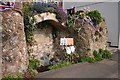
Lime kilns in Park Wood
These lime kilns were built in 1907 in Park Wood on the lower western slopes of the Malvern Hills. The lime was used on agriculatural land, earlier lime pits have been found nearby in Park Wood and date back to the mid 17th century.
Image: © Philip Halling
Taken: 13 Apr 2008
0.21 miles
10
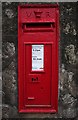
Post box, Royal Well
Built into the Malvern stone granite wall to the left of the water spout.
Image: © Bob Embleton
Taken: 3 May 2008
0.22 miles