IMAGES TAKEN NEAR TO
Worcester Road, MALVERN, WR14 4AB
Introduction
This page details the photographs taken nearby to Worcester Road, WR14 4AB by members of the Geograph project.
The Geograph project started in 2005 with the aim of publishing, organising and preserving representative images for every square kilometre of Great Britain, Ireland and the Isle of Man.

There are currently over 7.5m images from over14,400 individuals and you can help contribute to the project by visiting https://www.geograph.org.uk
Image Map
Images are licensed for reuse under creativecommons.org/licenses/by-sa/2.0
Notes
- Clicking on the map will re-center to the selected point.
- The higher the marker number, the further away the image location is from the centre of the postcode.
Image Listing (185 Images Found)
Images are licensed for reuse under creativecommons.org/licenses/by-sa/2.0
Image
Details
Distance
1
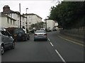
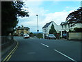
Great Malvern - Worcester Road near Bank Street
Image: © Peter Whatley
Taken: 21 Mar 2011
0.01 miles
2
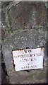
Milestone on Worcester Rd, Malvern
Cut mark on top of the milestone and also on the wall above. These marks were used by Ordnance Survey for mapping purposes.
Image: © V1ncenze
Taken: 30 Sep 2019
0.05 miles
3
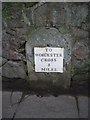
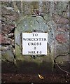
Old Milestone by the A449, Wells Road, Great Malvern
Metal plate attached to stone post by the A449, in parish of Malvern (Malvern Hills District), Wells Road, by No. 52; opposite Elm Bank Guest House, on the verge, on West side of road. Worcester Cross iron plate, erected by the Worcester turnpike trust in the 19th century.
Inscription reads:-
TO
WORCESTER
CROSS
8
MILES
Carved benchmark on top front.
Milestone Society National ID: WO_WOLB08
Image: © J Higgins
Taken: 1 Apr 2007
0.05 miles
4
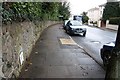
Milestone on the Worcester Road
Looking northwards towards Link top and Malvern Link.
The milestone on the left ("To Worcester Cross 8 Miles") has a wall built around and over it.
Large, late 18th/early 19th century houses line the eastern side of the road.
A recent dropped kerb crossing point has been added on the side of the pavement allowing wheelchair users easier access to the opposite side of the road.
The bobbled surface of the light yellow surface is to assist visually impaired pedestrians to locate the crossing point.
Image
Image: © Bob Embleton
Taken: 29 Mar 2010
0.06 miles
5
Milestone on the Worcester Road
To Worcester Cross 8 Miles.
The milestone has had a large Malvern granite wall built around it.
There is supposed to be a pivot bench mark on the top of the stone and the arrow mark is clearly visible, though the top is hidden by the wall.
There is, however, a horizontal mark on the wall above the stone.
The bench mark has been given the Waypoint number PV0146 on the bench mark database:-
http://www.bench-marks.org.uk/bm31278
Image: © Bob Embleton
Taken: 29 Mar 2010
0.06 miles
7

Malvern War Memorial and Library
Malvern's War Memorial has its list of the fallen inside the Library on white vellum. There is a time capsule beneath the memorial.
Image: © Bob Embleton
Taken: 16 Apr 2005
0.07 miles
8
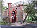
The Theatre of Small Convenience
Transformed from an old Victorian Gentleman's lavatory, the Theatre of Small Convenience is the smallest theatre in the world (building), in the Guinness Book of Records 2002.
Image: © Bob Embleton
Taken: 16 Apr 2005
0.07 miles
9
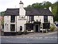
The Unicorn
Timber framed pub. Probably the oldest in Malvern. Upstairs used as a school 200 years ago.
Image: © Bob Embleton
Taken: 21 May 2005
0.07 miles
10

Malvern Library
Malvern Library on a spring afternoon.
Image: © Philip Halling
Taken: 30 May 2023
0.07 miles