IMAGES TAKEN NEAR TO
Charlock Road, MALVERN, WR14 3SR
Introduction
This page details the photographs taken nearby to Charlock Road, WR14 3SR by members of the Geograph project.
The Geograph project started in 2005 with the aim of publishing, organising and preserving representative images for every square kilometre of Great Britain, Ireland and the Isle of Man.

There are currently over 7.5m images from over14,400 individuals and you can help contribute to the project by visiting https://www.geograph.org.uk
Image Map (Loading...)


Getting Data...Please wait
Leaflet Map data © OpenStreetMap
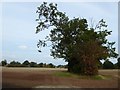
Images are licensed for reuse under creativecommons.org/licenses/by-sa/2.0
Notes
- Clicking on the map will re-center to the selected point.
- The higher the marker number, the further away the image location is from the centre of the postcode.
Image Listing (46 Images Found)
Images are licensed for reuse under creativecommons.org/licenses/by-sa/2.0
Image
Details
Distance
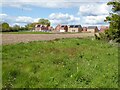
1
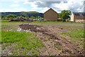
House building
House building beside Mill Lane near Poolbrook.
Image: © Philip Halling
Taken: 19 May 2021
0.01 miles
2
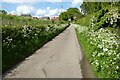
Mill Lane
Mill Lane near Poolbrook, new houses are being built on the land on the left. It's May and the verges are full of cow parsley.
Image: © Philip Halling
Taken: 19 May 2021
0.04 miles
3
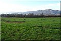
Land with planning permission pending
This field beside Mill Lane near Poolbrook in Malvern has planning permission pending for 63 new homes (43 homes for affordable/social rent and 20 affordable home). The Malvern Hills are in the background.
Image: © Philip Halling
Taken: 28 Dec 2018
0.04 miles
4
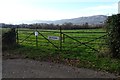
Gate to a field with pending planning permission
This field beside Mill Lane near Poolbrook in Malvern has planning permission pending for 63 new homes (43 homes for affordable/social rent and 20 affordable home). The Malvern Hills are in the background.
Image: © Philip Halling
Taken: 28 Dec 2018
0.06 miles
5
Farmland to the east of Mill Lane
Farmland to the east of Mill Lane near Guarlford.
Image: © Philip Halling
Taken: 26 Sep 2017
0.06 miles
6
New houses beside Mill Lane
New houses beside Mill Lane off the Guarlford Road area of Malvern.
Image: © Philip Halling
Taken: 6 May 2021
0.09 miles
7
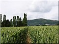
View Towards Mill Lane and Worcestershire Beacon
Looking west across arable land towards Mill Lane and the Worcestershire Beacon from the footpath behind the Green Dragon
Image: © Angus McCulloch
Taken: 20 Jun 2008
0.11 miles
8
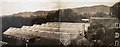
Tomato houses at The Elms, Barnard's Green
Built by the photographer's brother (contributor's grandfather) following his discharge from the Royal Navy and photographed from an attic window.
Some of the area covered by the glasshouses is now part of the relatively new development of Mallow Close.
Malvern Hills in the background.
For a view of the associated house taken around the same date see Image
Image: © R E Joan Batterham
Taken: Unknown
0.14 miles
9
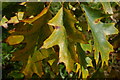
Autumn leaves
Autumn leaves on a tree on the Guarlford Road, Malvern.
Image: © Philip Halling
Taken: 12 Oct 2008
0.15 miles
10
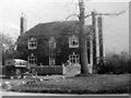
The Elms, Guarlford Road, Barnard's Green 1927
The house had no close neighbours to the west at this time.
The contributor's grandparents are seen just inside the gate.
See also Image
For a 2015 view of the same house see http://www.geograph.org.uk/photo/4720630
Image: © R E Joan Batterham
Taken: Unknown
0.16 miles