IMAGES TAKEN NEAR TO
Tudor Close, MALVERN, WR14 3SA
Introduction
This page details the photographs taken nearby to Tudor Close, WR14 3SA by members of the Geograph project.
The Geograph project started in 2005 with the aim of publishing, organising and preserving representative images for every square kilometre of Great Britain, Ireland and the Isle of Man.

There are currently over 7.5m images from over14,400 individuals and you can help contribute to the project by visiting https://www.geograph.org.uk
Image Map (Loading...)


Getting Data...Please wait
Leaflet Map data © OpenStreetMap
Images are licensed for reuse under creativecommons.org/licenses/by-sa/2.0
Notes
- Clicking on the map will re-center to the selected point.
- The higher the marker number, the further away the image location is from the centre of the postcode.
Image Listing (186 Images Found)
Images are licensed for reuse under creativecommons.org/licenses/by-sa/2.0
Image
Details
Distance
1
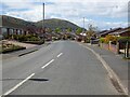
Brook Farm Drive
Brook Farm Drive in Poolbrook in Malvern. The North Hill of the Malvern Hills is in the background.
Image: © Philip Halling
Taken: 6 May 2021
0.05 miles
2

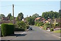
Brook Farm Drive
On the edge of Poolbrook, itself a suburb of Great Malvern.
Image: © Jonathan Billinger
Taken: 20 Oct 2008
0.06 miles
3
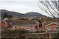
Bredon Grove, Malvern
Mostly bungalows on the southern stretch.
Many built on allotment land dating back to 1888 when the Foley Institute was opened on Poolbrook Common.
Image: © Bob Embleton
Taken: 29 May 2009
0.07 miles
4
Houses in the hollow, Brook Farm Drive
Looking from the high ground on one side of the hollow to the bungalows of Tudor Close (third row back).
In between are the two storey houses of Brook Farm Drive almost hidden in the dip.
19th century maps show water here called "New Pool" - perhaps a mill pool?
Image: © Bob Embleton
Taken: 16 Feb 2009
0.07 miles
5
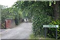
Knoll Lane, Poolbrook, Malvern
An unmetalled lane just north of St Andrews church off the common leading to a dozen houses.
Image: © Bob Embleton
Taken: 3 Jul 2009
0.08 miles
6

Bredon Grove, Poolbrook
Suburban housing on the east side of Malvern.
Image: © Des Blenkinsopp
Taken: 3 Nov 2022
0.09 miles
7
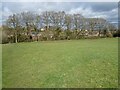
Bare oak trees
Bare oak trees in a hedgerow between a field and an early 1970s housing estate.
Image: © Philip Halling
Taken: 16 Mar 2021
0.09 miles
8
Poolbrook housing estate
The houses of Bredon Grove.
Many bungalows built on what had been allotments since the opening of the nearby Foley Institute in 1888.
Image: © Bob Embleton
Taken: 17 May 2009
0.10 miles
9
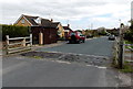
Bredon Road, Poolbrook, Malvern
The cattle grid is a reminder of a bygone era when livestock were kept on Poolbrook Common.
Image: © Jaggery
Taken: 5 May 2013
0.10 miles
10
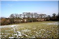
Field near Churchdown Road
Beyond the line of trees the expanding housing estates are waiting.
How soon before they advance over the surrounding green fields?
Image: © Bob Embleton
Taken: 8 Feb 2009
0.11 miles