IMAGES TAKEN NEAR TO
Ryle Way, WR14 3RW
Introduction
This page details the photographs taken nearby to Ryle Way, WR14 3RW by members of the Geograph project.
The Geograph project started in 2005 with the aim of publishing, organising and preserving representative images for every square kilometre of Great Britain, Ireland and the Isle of Man.

There are currently over 7.5m images from over14,400 individuals and you can help contribute to the project by visiting https://www.geograph.org.uk
Image Map (Loading...)


Getting Data...Please wait
Leaflet Map data © OpenStreetMap
Images are licensed for reuse under creativecommons.org/licenses/by-sa/2.0
Notes
- Clicking on the map will re-center to the selected point.
- The higher the marker number, the further away the image location is from the centre of the postcode.
Image Listing (621 Images Found)
Images are licensed for reuse under creativecommons.org/licenses/by-sa/2.0
Image
Details
Distance
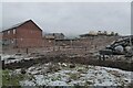
1
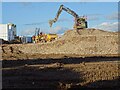
Construction work on Malvern Rise - 22 February 2021
Image: © Philip Halling
Taken: 22 Feb 2021
0.01 miles
2
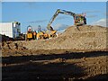
Construction work on Malvern Rise - 22 February 2021
Image: © Philip Halling
Taken: 22 Feb 2021
0.01 miles
3

Persimmon building site at Malvern Rise
Image: © Philip Halling
Taken: 26 Jan 2023
0.02 miles
4
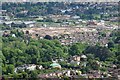
Demolition of the former Qinetiq site
Demolition of the former Qinetiq site in Malvern Viewed from the Malvern Hills near Upper Wyche.
Image: © Philip Halling
Taken: 12 May 2020
0.02 miles
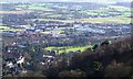
5
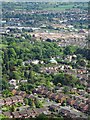
Demolition of the former Qinetiq site
Demolition of the former Qinetiq site viewed from on top of the Malvern Hills at the Upper Wyche. The Fruitlands estate can be seen in the near distance.
Image: © Philip Halling
Taken: 12 May 2020
0.02 miles
6

The former Qinetiq site
Much of the former Qinetiq site in Malvern has been demolished and is going to be built on by Persimmon Homes. Qinetiq is still on part of the site, the building in the background is a Qinetiq building.
Image: © Philip Halling
Taken: 3 Jan 2021
0.02 miles
8
QinetiQ / DSTL
Originally built as HMS Nelson during WWII, this became the home of the government's radar research establishment during peacetime. The name changed several times as it expanded and different ministries were in charge. Recently it has been privatised to become QinetiQ with a small section still under MOD control called the Defence Science and Technology Laboratory.
http://www.qinetiq.com/
http://www.dstl.gov.uk/
During the war the scientists occupied the public school Malvern College whose playing fields are visible in front of the picture.
Image: © Bob Embleton
Taken: 26 Jan 2008
0.02 miles
9
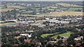
QinetiQ viewed from North Hill
Some of the old "temporary" war time buildings remain at what used to be the Royal Radar Establishment, though most have been demolished and replaced by new office buildings.
In front are the green playing fields of Malvern College where the radar establishment was established during the war.
Beyond is the open space of Malvern Common which has just been mown for hay.
Image: © Bob Embleton
Taken: 13 Sep 2009
0.03 miles
10
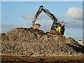
Excavator on the Persimmon site
After the demolition of the Qinetiq site the rubble from the demolished buildings is being removed from the site.
Image: © Philip Halling
Taken: 25 Feb 2021
0.04 miles