IMAGES TAKEN NEAR TO
Chance Lane, MALVERN, WR14 3QZ
Introduction
This page details the photographs taken nearby to Chance Lane, WR14 3QZ by members of the Geograph project.
The Geograph project started in 2005 with the aim of publishing, organising and preserving representative images for every square kilometre of Great Britain, Ireland and the Isle of Man.

There are currently over 7.5m images from over14,400 individuals and you can help contribute to the project by visiting https://www.geograph.org.uk
Image Map
Images are licensed for reuse under creativecommons.org/licenses/by-sa/2.0
Notes
- Clicking on the map will re-center to the selected point.
- The higher the marker number, the further away the image location is from the centre of the postcode.
Image Listing (16 Images Found)
Images are licensed for reuse under creativecommons.org/licenses/by-sa/2.0
Image
Details
Distance
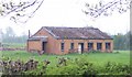
1
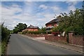
Agricultural workers' cottages, Hall Green
Post first world war social housing in Chance Lane. all now probably sold of as private houses.
Image: © Bob Embleton
Taken: 13 Jul 2008
0.03 miles
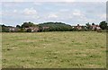
2
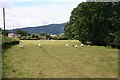
Sheep pasture, Grove House Farm
The modern metalled roadway to the farm runs to the left of the field but the old road (now a footpath) runs along a holloway on the right hand side of this field.
Image: © Bob Embleton
Taken: 13 Jul 2008
0.04 miles
3
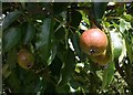
Pears in mid July
The small pears (probably a perry variety) are already well developed.
Image: © Bob Embleton
Taken: 13 Jul 2008
0.06 miles
4
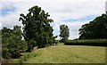
Pear tree near Grove House Farm
The footpath runs close to the left-hand hedge, Probably at the bottom of the sunken holloway.
Image: © Bob Embleton
Taken: 13 Jul 2008
0.08 miles
5
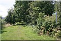
Old road, Hall Green
Now merely a footpath, but at one time a major routeway from Malvern to the river Severn at Clevelode.
Image: © Bob Embleton
Taken: 13 Jul 2008
0.15 miles
6
Wireless Telegraphy Site, Guarlford
Identified under the Defence of Britain Project as one of the country's first intelligence gathering sites. Now a humble farm shed.
Image: © Bob Embleton
Taken: 25 Apr 2005
0.16 miles
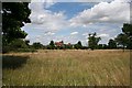
7
Cluster of houses in Chance Lane east of Malvern
Occasionally a little group of houses appeared in isolation on the plain
Image: © Andrew Darge
Taken: 17 Aug 2007
0.17 miles
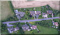
8
Houses in Chance Lane, Hall Green
Taken from the short footpath across the field to the west. The hill in the distance is Dripshill - an ideal site for a television transmitter for south- west Worcestershire.
Image: © Bob Embleton
Taken: 13 Jul 2008
0.17 miles
9
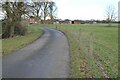
Grove House Farm
Drive approaching Grove House Farm.
Image: © Philip Halling
Taken: 22 Feb 2023
0.19 miles
10
Wide roadside verge, Hall Green
The verge beside the "Guarlford Straight" opens out into a fairly wide stretch of common land with the houses set back a very long way from the road.
Image: © Bob Embleton
Taken: 13 Jul 2008
0.21 miles