IMAGES TAKEN NEAR TO
St. Andrews Road, MALVERN, WR14 3PU
Introduction
This page details the photographs taken nearby to St. Andrews Road, WR14 3PU by members of the Geograph project.
The Geograph project started in 2005 with the aim of publishing, organising and preserving representative images for every square kilometre of Great Britain, Ireland and the Isle of Man.

There are currently over 7.5m images from over14,400 individuals and you can help contribute to the project by visiting https://www.geograph.org.uk
Image Map
Images are licensed for reuse under creativecommons.org/licenses/by-sa/2.0
Notes
- Clicking on the map will re-center to the selected point.
- The higher the marker number, the further away the image location is from the centre of the postcode.
Image Listing (688 Images Found)
Images are licensed for reuse under creativecommons.org/licenses/by-sa/2.0
Image
Details
Distance
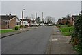
1
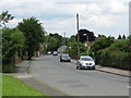
Malvern Wells - St Andrew's Road
Taken from the junction with Peachfield Road
Image: © Peter Whatley
Taken: 6 Jun 2008
0.01 miles
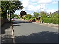
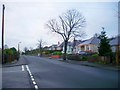
2
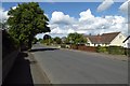
St Andrew's Road
St Andrew's Road in Malvern is a mix of bungalows, both pre and post-war, large Victorian houses and infill houses.
Image: © Philip Halling
Taken: 5 Aug 2017
0.02 miles
3
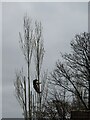
A tree surgeon at work
A tree surgeon at work cutting back a tree beside St Andrews Road.
Image: © Philip Halling
Taken: 3 Apr 2021
0.03 miles
4
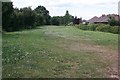
Route of the old railway
This was a deep cutting carrying the Malvern to Upton railway. It was filled in during the expansion of the nearby Royal Signals and Radar Establishment. Excavations there needed a landfill site.
Image: © Bob Embleton
Taken: 3 Jul 2008
0.03 miles
5
Bernard Drive
Bernard Drive, a 1960s housing estate in Malvern.
Image: © Philip Halling
Taken: 15 Dec 2018
0.04 miles
6
St Andrew's Road
St Andrew's Road in Malvern has mix of housing including late Victorian, inter-war bungalows and post-war houses.
Image: © Philip Halling
Taken: 31 Aug 2019
0.04 miles
7
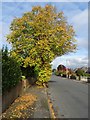
Lime tree on St Andrew's Road
A lime tree in colours on St Andrew's Road.
Image: © Philip Halling
Taken: 21 Oct 2019
0.04 miles
8
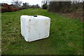
Flying tipping on Malvern Common
From a distance I thought this had been blown here by Storm Franklin but it appears to be the result of fly tipping.
Image: © Philip Halling
Taken: 20 Feb 2022
0.04 miles
9
St. Andrews Road, Malvern
The southern end of the road with older bungalows squeezed between the road and the route of the old railway line behind.. One is adorned with Christmas lights.
Image: © Bob Embleton
Taken: 14 Dec 2008
0.04 miles
10
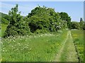
Bridleway on Malvern Common
Spring on Malvern Common, cow parsley and hawthorn is in flower. This shows roughly the trackbed of the former Malvern to Ashchurch railway line. The line between Malvern and Upton-upon-Severn closed in 1952.
Image: © Philip Halling
Taken: 20 May 2018
0.04 miles