IMAGES TAKEN NEAR TO
Ellerslie Drive, MALVERN, WR14 3NY
Introduction
This page details the photographs taken nearby to Ellerslie Drive, WR14 3NY by members of the Geograph project.
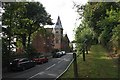
The Geograph project started in 2005 with the aim of publishing, organising and preserving representative images for every square kilometre of Great Britain, Ireland and the Isle of Man.

There are currently over 7.5m images from over14,400 individuals and you can help contribute to the project by visiting https://www.geograph.org.uk
Image Map
Images are licensed for reuse under creativecommons.org/licenses/by-sa/2.0
Notes
- Clicking on the map will re-center to the selected point.
- The higher the marker number, the further away the image location is from the centre of the postcode.
Image Listing (195 Images Found)
Images are licensed for reuse under creativecommons.org/licenses/by-sa/2.0
Image
Details
Distance
1
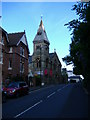
Malvern Baptist Church, Abbey Road, Malvern
Viewed from atop the tower of Malvern Priory church. Above the church is the Tudor hotel, once one of the first "Water Cure" establishments in the early 1840s.
Image: © Bob Embleton
Taken: 8 Sep 2001
0.03 miles
2
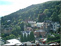
Countess of Huntingdon's Chapel, Wells Road
A long distance shot exposing the elevated position of the buildings on the Wells Road.
The chapels were part of the great 18th century non-conformist revival under the Methodist movement. http://en.wikipedia.org/wiki/Countess_of_Huntingdon
Now a fitness centre.
Many of the buildings around the chapel (apart from the 1960s block of flats) are connected with Malvern College.
Image: © Bob Embleton
Taken: 14 Jun 2009
0.04 miles
3
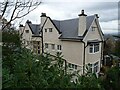
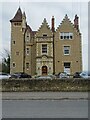
Malvernbury House
Malvernbury House was built in the early 20th century on the site of an earlier house named Malvernbury where Florence Nightingale stayed on a number of occasions. This had been a care home but has been recently redeveloped and converted into apartments.
Image: © Philip Halling
Taken: 11 Nov 2020
0.04 miles
4
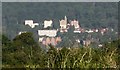
Countess of Huntingdon's Church, Wells Road
Now a fitness centre.
The path on the right climbs up to Foley Terrace.
Image: © Bob Embleton
Taken: 2 Aug 2009
0.05 miles
5
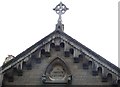
Gable end, Countess of Huntingdon's Church
Bearing the inscription "In Veritate Victoria" ("Victory in Truth")
Image
Image: © Bob Embleton
Taken: 2 Aug 2009
0.05 miles
6
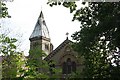
Roof of the Countess of Huntingdon's Church
It appears that the covering on the spire is in need of attention.
Image: © Bob Embleton
Taken: 2 Aug 2009
0.05 miles
7
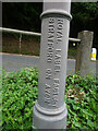
Fingerpost pillar, Malvern
Manufacturers name on the fingerpost at the junction of Wells Road A449 and Wyche Road B4218 within the acute angle. 2 arms and annulus finial. For the view in full see Image
Inscription: Royal Label Factory / Stratford on Avon
Milestone Society National ID: WO_SO7745
Image: © Mr Red
Taken: 8 Sep 2022
0.05 miles
8
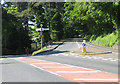
Wyche Road meets Wells Road
B4218 meets A449.
Image: © Pauline E
Taken: 31 May 2009
0.05 miles
9
Elmsdale on Abbey Road
Elmsdale is a fine example of the many varied Victorian houses in Malvern; it was built about 1853 for Dr James Loftus Marsden to treat his water cure patients. However, by the 1861 census it was occupied by Miss Caroline Cooper who ran a Ladies' School.
Image: © Philip Halling
Taken: 7 Mar 2021
0.05 miles