IMAGES TAKEN NEAR TO
Barnards Close, MALVERN, WR14 3NJ
Introduction
This page details the photographs taken nearby to Barnards Close, WR14 3NJ by members of the Geograph project.
The Geograph project started in 2005 with the aim of publishing, organising and preserving representative images for every square kilometre of Great Britain, Ireland and the Isle of Man.

There are currently over 7.5m images from over14,400 individuals and you can help contribute to the project by visiting https://www.geograph.org.uk
Image Map (Loading...)


Getting Data...Please wait
Leaflet Map data © OpenStreetMap
Images are licensed for reuse under creativecommons.org/licenses/by-sa/2.0
Notes
- Clicking on the map will re-center to the selected point.
- The higher the marker number, the further away the image location is from the centre of the postcode.
Image Listing (138 Images Found)
Images are licensed for reuse under creativecommons.org/licenses/by-sa/2.0
Image
Details
Distance
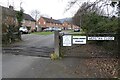
2
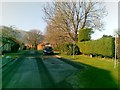
Werstan Close, Malvern
On the west side of Poolbrook Road. A grid across the road is designed to keep out unwelcome 4-legged creatures. The Neighbourhood Watch notice is designed to keep out unwelcome 2-legged creatures.
Image: © Jaggery
Taken: 5 May 2013
0.03 miles
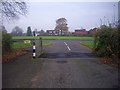
3
Werstan Close from Poolbrook Common
Werstan Close is a circular development of 24 houses arranged in eight blocks of three.
The close was built in the days when the common was occupied by animals for it has a cattle grid at its access complete with a gate to allow horse drawn vehicles to pass.
How times change.
Image: © Bob Embleton
Taken: 28 Feb 2009
0.04 miles
4
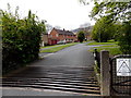
Cattle grid at the entrance to Werstan Close
This close of Poolbrook Road is named after one of Malvern's first residents, St Werstan who sought sanctuary in Malvern after the Anglo-Saxon monastery of Deerhurst was raided by Norsemen.
Image: © Philip Halling
Taken: 3 Oct 2022
0.06 miles
5
Entrance to Werstan Close
Cattle grid at the entrance to Werstan Close. The close is named after St Werstan, a monk from the Anglo-Saxon monastery of Deerhurst near Tewkesbury, who fled to Malvern Chase after Deerhurst was attacked by Vikings.
Image: © Philip Halling
Taken: 28 Jan 2022
0.06 miles
6
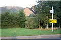
Temporary signs in Poolbrook
The VW Vanfest is taking place at the nearby Three Counties Showground.
attempts are being made with signage to control the flow and make the event tolerable for local road users.
Worcestershire Beacon in the background.
Image: © Bob Embleton
Taken: 11 Sep 2009
0.07 miles
7

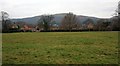
Common land and trees by Poolbrook Road
This area is where three neighbourhoods meet. On the left, Barnard's Green, ahead, Pound Bank, and on the right, Poolbrook. The road on the left leads to Werstan Close, originally built to house staff at the Royal Radar Establishment.
Image: © David Smith
Taken: 13 Jan 2014
0.09 miles
8
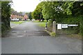
Exit from Werstan Close
Here the access is onto Poolbrook Common. Note the cattle grid and access for horse draw vehicles. I doubt if either have been of use for several decades. The farmers and commoners who used to graze their animals have suffered from the speeding motorist and the unleashed dogs. St. Werstan was said to have lived in a hermitage on the Malvern Hills in the 9th century - long before the Priory and the susaquent village and town of Great Malvern existed.
Image: © Bob Embleton
Taken: 30 Nov 2008
0.09 miles
10
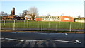
Annexe of Chase School
Annexe buildings, part of the Chase School in Malvern, the main buildings of the school are to the south of Geraldine Road.
Image: © Philip Halling
Taken: 29 Dec 2017
0.10 miles