IMAGES TAKEN NEAR TO
Ellerslie Drive, MALVERN, WR14 3LX
Introduction
This page details the photographs taken nearby to Ellerslie Drive, WR14 3LX by members of the Geograph project.
The Geograph project started in 2005 with the aim of publishing, organising and preserving representative images for every square kilometre of Great Britain, Ireland and the Isle of Man.

There are currently over 7.5m images from over14,400 individuals and you can help contribute to the project by visiting https://www.geograph.org.uk
Image Map (Loading...)


Getting Data...Please wait
Leaflet Map data © OpenStreetMap
Images are licensed for reuse under creativecommons.org/licenses/by-sa/2.0
Notes
- Clicking on the map will re-center to the selected point.
- The higher the marker number, the further away the image location is from the centre of the postcode.
Image Listing (175 Images Found)
Images are licensed for reuse under creativecommons.org/licenses/by-sa/2.0
Image
Details
Distance
1
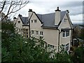
Malvernbury House
Malvernbury House was built in the early 20th century on the site of an earlier house named Malvernbury where Florence Nightingale stayed on a number of occasions. This had been a care home but has been recently redeveloped and converted into apartments.
Image: © Philip Halling
Taken: 11 Nov 2020
0.04 miles
2
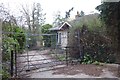
Awaiting redevelopment
What appears to be a lodge on Abbey Road is fenced off and awaits redevelopment.
Image: © Philip Halling
Taken: 8 Jan 2018
0.05 miles
3
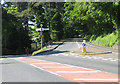
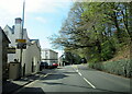
Wyche Road meets Wells Road
B4218 meets A449.
Image: © Pauline E
Taken: 31 May 2009
0.05 miles
4
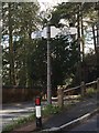
Direction Sign ? Signpost on the A449 Wells Road in Malvern Wells
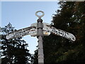
Located on the south side of the junction of the A449 Wells Road and Wyche Road in Malvern Wells parish. 2 arms and annulus finial. For an image of the embossed manufacturer's name see ImageSee also https://www.geograph.org.uk/photo/1336923 , https://www.geograph.org.uk/photo/6841687 and https://www.geograph.org.uk/photo/7007023.
Milestone Society National ID: WO_SO7745
Image: © Jan Scrine
Taken: 2 Mar 2020
0.05 miles
5
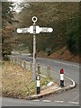
Direction Sign ? Signpost on the A449 Wells Road in Malvern Wells
Located on the south side of the junction of the A449 Wells Road and Wyche Road in Malvern Wells parish. 2 arms and annulus finial. A photo of https://www.geograph.org.uk/photo/6565780 before it was restored. For an image of the embossed manufacturer's name see ImageSee also https://www.geograph.org.uk/photo/1336923 and https://www.geograph.org.uk/photo/6841687.
Milestone Society National ID: WO_SO7745
Image: © Roadside Relics
Taken: 10 Oct 2018
0.05 miles
6
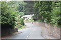
A449 Malvern approaching junction with B4218
Image: © Roy Hughes
Taken: 24 Apr 2021
0.05 miles
7
Signpost on Wyche Road
Signpost on the junction of Wells Road and Wyche Road.
Image: © Philip Halling
Taken: 11 Feb 2021
0.05 miles
8
Abbey Road
A view of the southern end of Abbey Road as it climbs to meet the A449 Wells Road.
The pedestrian crossing lights were introduced for the public school children from the Ellerslie boarding school (now part of Malvern College).
The main buildings of Malvern College are in College Road which joins on the left.
Image: © Bob Embleton
Taken: 25 Aug 2010
0.05 miles
9
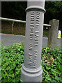
Fingerpost pillar, Malvern
Manufacturers name on the fingerpost at the junction of Wells Road A449 and Wyche Road B4218 within the acute angle. 2 arms and annulus finial. For the view in full see Image
Inscription: Royal Label Factory / Stratford on Avon
Milestone Society National ID: WO_SO7745
Image: © Mr Red
Taken: 8 Sep 2022
0.05 miles
10
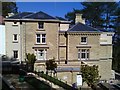
Audley Ellerslie
Retirement home, which was originally Ellerslie Girls School.
Image: © Trevor Rickard
Taken: 19 Apr 2020
0.06 miles