IMAGES TAKEN NEAR TO
Madresfield Road, MALVERN, WR14 3LL
Introduction
This page details the photographs taken nearby to Madresfield Road, WR14 3LL by members of the Geograph project.
The Geograph project started in 2005 with the aim of publishing, organising and preserving representative images for every square kilometre of Great Britain, Ireland and the Isle of Man.

There are currently over 7.5m images from over14,400 individuals and you can help contribute to the project by visiting https://www.geograph.org.uk
Image Map (Loading...)


Getting Data...Please wait
Leaflet Map data © OpenStreetMap
Images are licensed for reuse under creativecommons.org/licenses/by-sa/2.0
Notes
- Clicking on the map will re-center to the selected point.
- The higher the marker number, the further away the image location is from the centre of the postcode.
Image Listing (343 Images Found)
Images are licensed for reuse under creativecommons.org/licenses/by-sa/2.0
Image
Details
Distance
1
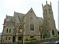
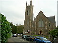
The Methodist Church, Lansdowne Crescent
A very large towered building for the Methodists of Great Malvern; clearly making a statement in what was an up-and-coming town in Victorian times.
Image: © Jonathan Billinger
Taken: 15 Sep 2009
0.01 miles
2
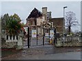
Demolition of former Malvern Hospital
Demolition work underway on the former Malvern Community Hospital.
Image: © Philip Halling
Taken: 22 Nov 2019
0.01 miles
3
Demolition of the former Malvern Hospital
Demolition work underway on the former Malvern Community Hospital.
Image: © Philip Halling
Taken: 22 Nov 2019
0.01 miles
4
Demolition of the former Malvern Community Hospital
Demolition work underway on the former Malvern Community Hospital.
Image: © Philip Halling
Taken: 22 Nov 2019
0.01 miles
5
Demolition of the former Malvern Hospital
Demolition work underway on the former Malvern Community Hospital.
Image: © Philip Halling
Taken: 22 Nov 2019
0.01 miles
6
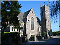
The Methodist Church, Lansdowne Crescent
A very large towered building for the Methodists of Great Malvern; clearly making a statement in what was an up-and-coming town in Victorian times.
View from the west.
Image: © Jonathan Billinger
Taken: 15 Sep 2009
0.02 miles
7
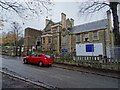
Lansdowne Methodist Church Lansdowne Crescent
Image: © James Pratt
Taken: 31 May 2010
0.02 miles
8
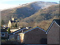
Lansdowne Church and the Worcestershire Beacon
View south-west from Fernhill Grove. Heavy rains the night before fell as snow above 1,000 metres.
Image: © Trevor Rickard
Taken: 12 Jan 2008
0.02 miles
9
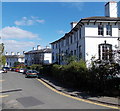
Lansdowne Crescent, Malvern
Looking east along 3 rows of 4 houses.
Image: © Jaggery
Taken: 5 May 2013
0.02 miles
10
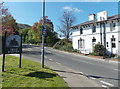
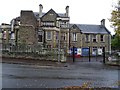
Great Malvern boundary sign
Located on a small area of grass at the junction of Imperial Road and the B4211 Barnard's Green Road.
Image: © Jaggery
Taken: 5 May 2013
0.02 miles