IMAGES TAKEN NEAR TO
Bellmere Gardens, MALVERN, WR14 3HQ
Introduction
This page details the photographs taken nearby to Bellmere Gardens, WR14 3HQ by members of the Geograph project.
The Geograph project started in 2005 with the aim of publishing, organising and preserving representative images for every square kilometre of Great Britain, Ireland and the Isle of Man.

There are currently over 7.5m images from over14,400 individuals and you can help contribute to the project by visiting https://www.geograph.org.uk
Image Map (Loading...)


Getting Data...Please wait
Leaflet Map data © OpenStreetMap
Images are licensed for reuse under creativecommons.org/licenses/by-sa/2.0
Notes
- Clicking on the map will re-center to the selected point.
- The higher the marker number, the further away the image location is from the centre of the postcode.
Image Listing (114 Images Found)
Images are licensed for reuse under creativecommons.org/licenses/by-sa/2.0
Image
Details
Distance
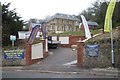
1
Former school
The former Hampton School on College Road. One of a number of former schools in Malvern, it has recently been refurbished and converted into apartments.
Image: © Philip Halling
Taken: 7 Mar 2021
0.01 miles
2
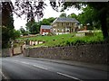
Refurbished house
Refurbished house on College Road.
Image: © Philip Halling
Taken: 13 May 2020
0.01 miles
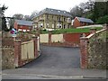
3
Housing development
Housing development on College Road in Malvern.
Image: © Philip Halling
Taken: 8 Jan 2018
0.02 miles
4
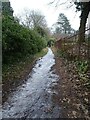
An icy footpath
This footpath from Thirlestane Road to Wells Road is quite steep and at present is slippery as the water which is flowing down the path after rain has frozen.
Image: © Philip Halling
Taken: 14 Feb 2021
0.03 miles
5
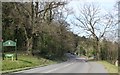
Welcome to Malvern
The southern edge of Great Malvern Parish. Viewed on the Wells Road travelling north across Malvern common from the Lower Wyche area. Here we have a welcome notice and a milestone showing that it is only 9 miles to Worcester Cross.
Image: © Bob Embleton
Taken: 6 Apr 2007
0.04 miles
6
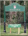
Welcome to Malvern (Detail)
Detail of the gold on green sign welcoming visitors travelling north along the A449 from Malvern Wells and about to enter Great Malvern parish. I am puzzled as to why it doesn't say Great Malvern as there are many Malverns around the Malvern Hills.
Image: © Bob Embleton
Taken: 6 Apr 2007
0.05 miles
7
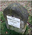
Bench Mark on a milestone
Known as a Pivot Bench Mark and assigned the number : PV0151
From the first primary levelling of England & Wales (1840 - 1860).
This suggests that the milestone dates from before 1860.
Image
Image
Image: © Bob Embleton
Taken: 26 Mar 2010
0.06 miles
8
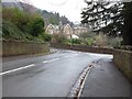
Junction of Thurlstane Road and College Road
Junction of Thurlstane Road and College Road in Malvern.
Image: © Philip Halling
Taken: 6 Jan 2017
0.06 miles
9

Remains of a kissing gate
The remains of a kissing gate on a footpath off Thirlstane Road in Malvern.
Image: © Philip Halling
Taken: 16 Sep 2017
0.06 miles
10
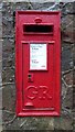
Georgian letterbox
Georgian letterbox on Thurlstaine Road in Malvern.
Image: © Philip Halling
Taken: 6 Jan 2017
0.06 miles