IMAGES TAKEN NEAR TO
Wordsworth Green, MALVERN, WR14 2UG
Introduction
This page details the photographs taken nearby to Wordsworth Green, WR14 2UG by members of the Geograph project.
The Geograph project started in 2005 with the aim of publishing, organising and preserving representative images for every square kilometre of Great Britain, Ireland and the Isle of Man.

There are currently over 7.5m images from over14,400 individuals and you can help contribute to the project by visiting https://www.geograph.org.uk
Image Map
Images are licensed for reuse under creativecommons.org/licenses/by-sa/2.0
Notes
- Clicking on the map will re-center to the selected point.
- The higher the marker number, the further away the image location is from the centre of the postcode.
Image Listing (128 Images Found)
Images are licensed for reuse under creativecommons.org/licenses/by-sa/2.0
Image
Details
Distance
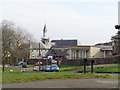
1
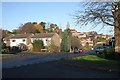
Tennyson Drive
Tennyson Drive and Wordsworth Green.
Part of a 1980s housing estate themed on poets.
This area is private housing: detached and semi-detached.
Image: © Bob Embleton
Taken: 6 Dec 2009
0.03 miles
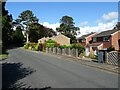
3
Tennyson Drive
Part of an early 1980s housing estate using the surnames of poets in the address.
Image: © Bob Embleton
Taken: 6 Dec 2009
0.06 miles
4
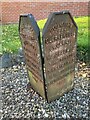
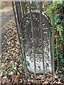
Old Boundary Marker on Cockshot Road, Malvern
Estate Boundary Marker visible from the road behind railings in a front garden on the west side of Cockshot Road opposite Tennyson Drive. Malvern parish. Cockshute Farm Estate was acquired in 1658 by Sir George Strode and he donated the income to the parish church and poor hospital of St. James in Clerkenwell, London. The posts were erected in the mid-1800s to mark the boundary of the estate. 25 were shown on a map of 1884 and many survive in gardens as the estate has been developed for housing. Grade II Listed details https://historicengland.org.uk/listing/the-list/list-entry/1393186.
Milestone Society National ID: WO_CLERK08em
Image: © J Scrine
Taken: 22 Nov 2021
0.07 miles
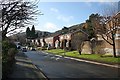
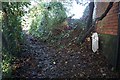
5
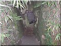
Steps down to Tunnel, Davenham, Malvern
The well stocked gardens of Davenham extend to the east of Cockshot Road and a tunnel beneath the road provided access, though unfortunately locked these days.
Image: © Bob Embleton
Taken: 20 May 2006
0.08 miles
6
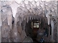
The Tunnel beneath Cockshot Road, Davenham, Malvern
Concrete stalagmites and stalactites decorate this tunnel joining gardens belonging to Davenham - once owned by the Perrins family of Worcester Sauce fame.
Image: © Bob Embleton
Taken: 20 May 2006
0.08 miles
7
Old Boundary Marker between Moorlands Road and Tennyson Drive, Malvern
Estate Boundary Marker Behind railings on a footpath off Moorlands Road after a cattle grid to Little Davenham house. Malvern parish. Cockshute Farm Estate was acquired in 1658 by Sir George Strode and he donated the income to the parish church and poor hospital of St. James in Clerkenwell, London. The posts were erected in the mid-1800s to mark the boundary of the estate. 25 were shown on a map of 1884 and many survive in gardens as the estate has been developed for housing.
Milestone Society National ID: WO_CLERK05em
Image: © J Scrine
Taken: 22 Nov 2021
0.08 miles
8
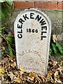
Old Boundary Marker off Moorlands Road, Malvern
Estate Boundary Marker beside a footpath starting from Moorlands Road. Malvern parish. Cockshute Farm Estate was acquired in 1658 by Sir George Strode and he donated the income to the parish church and poor hospital of St. James in Clerkenwell, London. The posts were erected in the mid-1800s to mark the boundary of the estate. 25 were shown on a map of 1884 and many survive in gardens as the estate has been developed for housing. Grade II Listed details https://historicengland.org.uk/listing/the-list/list-entry/1393186.
Milestone Society National ID: WO_CLERK01em
Image: © J Scrine
Taken: 22 Nov 2021
0.08 miles
9
Perrins House, Moorlands Road, Malvern Link
Perrins House is a purposes built care home set in extensive grounds with a wide range of rare and exotic trees and shrubs.
Image: © Jeff Gogarty
Taken: 12 Mar 2016
0.10 miles
10
Clerkenwell marker on path near Moorlands Road
The path runs from Moorlands Road to Tennyson Drive following a Victorian-looking iron fence.
The cast iron marker is one of many that mark out the limits to land once owned by the parish of Clerkenwell in London.
Image: © Bob Embleton
Taken: 6 Dec 2009
0.11 miles