IMAGES TAKEN NEAR TO
Sling Lane, MALVERN, WR14 2TU
Introduction
This page details the photographs taken nearby to Sling Lane, WR14 2TU by members of the Geograph project.
The Geograph project started in 2005 with the aim of publishing, organising and preserving representative images for every square kilometre of Great Britain, Ireland and the Isle of Man.

There are currently over 7.5m images from over14,400 individuals and you can help contribute to the project by visiting https://www.geograph.org.uk
Image Map (112 Images)


Getting Data...Please wait
Leaflet Map data © OpenStreetMap
Images are licensed for reuse under creativecommons.org/licenses/by-sa/2.0
Notes
- Clicking on the map will re-center to the selected point.
- The higher the marker number, the further away the image location is from the centre of the postcode.
Image Listing (112 Images Found)
Images are licensed for reuse under creativecommons.org/licenses/by-sa/2.0
Image
Details
Distance
1
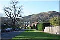
Sling Lane
Sling Lane runs down from Albert Road North to the railway line.
The routeway once continued under the railway bridge and on to Madresfield, though this is now limited to a footpath.
North Hill in the distance.
Image: © Bob Embleton
Taken: 6 Dec 2009
0.07 miles
2
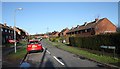
Clerkenwell Crescent
Post war Ministry housing for married scientists coming to Malvern to work at the (then) Radar Research Establishment.
Now social housing except for those purchased by the occupants.
The name Clerkenwell Crescent comes from the fact that land near here was owned by the parish of Clerkenwell in London.
Image: © Bob Embleton
Taken: 6 Dec 2009
0.07 miles
3
Ministry Housing
Clerkenwell Crescent and Davenham Close were built to house married scientists moving to Malvern to work at the Royal Radar Establishment after World War II.
Now sold to the occupants or taken over by the Elgar Housing Association.
Image: © Bob Embleton
Taken: 26 Jan 2008
0.08 miles
4
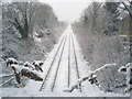
Railway line to Worcester
From the Madresfield Road bridge looking north along the straight lines leading to Malvern Link station. Trains are running normally despite the snow.
Image: © Trevor Rickard
Taken: 6 Feb 2009
0.10 miles
5
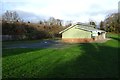
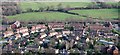
Sling Lane Playing Fields
Sling Lane Playing Fields in Malvern.
Image: © Philip Halling
Taken: 30 Dec 2018
0.11 miles
6
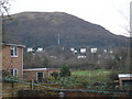
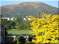
Playing fields and North Hill
View north-east from our garden across the playing field and railway embankment towards the TV mast and North Hill. Christmas Day 2007 is dull, but at least it has stopped raining and the mist has just cleared off the top of the hill.
Image: © Trevor Rickard
Taken: 25 Dec 2007
0.12 miles
7
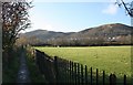
Footpath to Sling Lane
The route takes one from Madresfield to Great Malvern.
The field on the right is one of several to the east of the railway line that may soon be developed for housing according to local plans.
The two hills in view are Worcestershire Beacon on the left with North Hill on the right which has the local TV transmitter clearly visible on its lower slopes.
Image: © Bob Embleton
Taken: 6 Dec 2009
0.12 miles
8
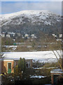
Train approaching Great Malvern
View west across the snowy playing fields towards North Hill. On the embankment a Central Trains unit is slowing as it approaches Great Malvern station just off to the left.
Image: © Trevor Rickard
Taken: 7 Feb 2009
0.12 miles
9
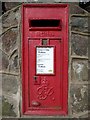
Georgian letterbox, Albert Road North
George V letterbox on the corner of Albert North Road and Sling Lane in Great Malvern.
Image: © Philip Halling
Taken: 27 Feb 2016
0.13 miles
10
Playing fields in Great Malvern
Looking westwards across the town centre fields to the railway embankment and North Hill beyond. Also in view is the town TV transmitter.
Image: © Trevor Rickard
Taken: 5 Oct 2007
0.13 miles