IMAGES TAKEN NEAR TO
Five Oaks Close, MALVERN, WR14 2SW
Introduction
This page details the photographs taken nearby to Five Oaks Close, WR14 2SW by members of the Geograph project.
The Geograph project started in 2005 with the aim of publishing, organising and preserving representative images for every square kilometre of Great Britain, Ireland and the Isle of Man.

There are currently over 7.5m images from over14,400 individuals and you can help contribute to the project by visiting https://www.geograph.org.uk
Image Map
Images are licensed for reuse under creativecommons.org/licenses/by-sa/2.0
Notes
- Clicking on the map will re-center to the selected point.
- The higher the marker number, the further away the image location is from the centre of the postcode.
Image Listing (5 Images Found)
Images are licensed for reuse under creativecommons.org/licenses/by-sa/2.0
Image
Details
Distance
1
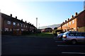
Moat Crescent to Moat Way, Malvern
Social housing estate on the edge of Malvern.
Image: © Bob Embleton
Taken: 3 Dec 2014
0.16 miles
2
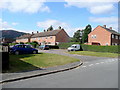
Moat Crescent/Moatway, Great Malvern
Older housing on the eastern outskirts of the town.
Image: © Jonathan Billinger
Taken: 1 Oct 2009
0.16 miles
3
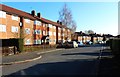
Moat Crescent, Malvern
Social housing on the edge of Malvern.
Close to Moat Court a medieval site from which the crescent gets its name.
Image: © Bob Embleton
Taken: 3 Dec 2014
0.18 miles
4
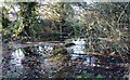
Pond, Sherrard's Green, Malvern
A dumping ground; too close to the housing estate.
Image: © Bob Embleton
Taken: 3 Dec 2014
0.23 miles
5
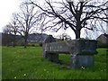
Horse Trough, Barnards Green, Malvern
Malvern's only Boer War Memorial dedicated to the horses that died in battle in South Africa. Erected in 1901 by the MSPCA (Malvern Society for the Prevention of Cruelty to Animals).
Image: © Bob Embleton
Taken: 14 Apr 2005
0.24 miles