IMAGES TAKEN NEAR TO
Zetland Road, MALVERN, WR14 2JH
Introduction
This page details the photographs taken nearby to Zetland Road, WR14 2JH by members of the Geograph project.
The Geograph project started in 2005 with the aim of publishing, organising and preserving representative images for every square kilometre of Great Britain, Ireland and the Isle of Man.

There are currently over 7.5m images from over14,400 individuals and you can help contribute to the project by visiting https://www.geograph.org.uk
Image Map (Loading...)


Getting Data...Please wait
Leaflet Map data © OpenStreetMap
Images are licensed for reuse under creativecommons.org/licenses/by-sa/2.0
Notes
- Clicking on the map will re-center to the selected point.
- The higher the marker number, the further away the image location is from the centre of the postcode.
Image Listing (185 Images Found)
Images are licensed for reuse under creativecommons.org/licenses/by-sa/2.0
Image
Details
Distance
1
B4232 North Malvern Road at junction with A449
Image: © Roy Hughes
Taken: 24 Apr 2021
0.01 miles
2
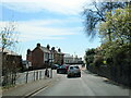
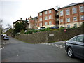
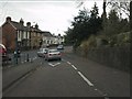
Zetland Road, Malvern
Taken from the Bank Street crossroads.
The road is quite narrow at the top and too awkward a junction with the busy A449 Worcester Road at the top to allow traffic to proceed uphill.
Note the Malvern granite walls.
Image: © Bob Embleton
Taken: 1 Sep 2011
0.02 miles
3
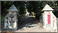
Entrance to the Holy Trinity churchyard
The driveway starts here on Worcester Road.
The church was built in 1851 as the Malvern Water cure was turning Malvern into a boom town.
http://www.holytrinitymalvern.org.uk/5.html
Image: © Bob Embleton
Taken: 1 Sep 2011
0.02 miles
4
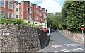
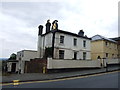
The old Malvern Police Station, Worcester Road
Now a block of modern apartments.
The old police station was, for many decades, a motorbike shop and repair workshop.
Some of the "newer" additional buildings were demolished and new construction matching the style and external materials of the old police station took place.
This view is from the junction of Back Lane and Zetland Road.
Just in front Bank Street crosses Zetland Road.
Image: © Bob Embleton
Taken: 1 Sep 2011
0.03 miles
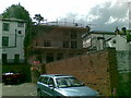
7
Rear of the Plymouth Brethren meeting house.
An old, large-scale OS map describes this as:
"Meeting House (Plymouth Brethren) (seats for 200)".
The notice above the door reads:
"You are invited to hear
THE WORD OF GOD
preached here on Lord's Day (Sunday) at 5:00 pm
God willing"
Image: © Bob Embleton
Taken: 1 Sep 2011
0.04 miles
8
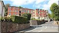
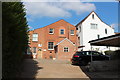
4 new flats, Worcester Road, Great Malvern
Image: © Alex McGregor
Taken: 7 Jun 2011
0.04 miles
9
North Malvern Road meets Worcester Road
A busy junction with blind sightlines both ways and heavy traffic on all routes. Typical of local roads in the Malvern area and symptomatic of the town centre's decline in favour of more accessible retail parks.
Image: © Peter Whatley
Taken: 21 Mar 2011
0.04 miles
10
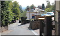
Zetland Road, Malvern
Looking down the fairly steep Zetland Road.
Bank Street crosses from left to right on its less steep climb to the busy Worcester Road.
Image: © Bob Embleton
Taken: 1 Sep 2011
0.04 miles