IMAGES TAKEN NEAR TO
Oxford Road, MALVERN, WR14 2JD
Introduction
This page details the photographs taken nearby to Oxford Road, WR14 2JD by members of the Geograph project.
The Geograph project started in 2005 with the aim of publishing, organising and preserving representative images for every square kilometre of Great Britain, Ireland and the Isle of Man.

There are currently over 7.5m images from over14,400 individuals and you can help contribute to the project by visiting https://www.geograph.org.uk
Image Map
Images are licensed for reuse under creativecommons.org/licenses/by-sa/2.0
Notes
- Clicking on the map will re-center to the selected point.
- The higher the marker number, the further away the image location is from the centre of the postcode.
Image Listing (183 Images Found)
Images are licensed for reuse under creativecommons.org/licenses/by-sa/2.0
Image
Details
Distance
1
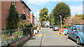
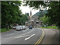
Oxford Road, Link Top, Malvern
Overlooking a small section of the most southerly area of Malvern Link Common.
Taken from its junction with Lygon Bank.
The road is now a cul-de-sac, but used to emerge, at the far end, onto the Worcester Road at a very complex multiple road junction.
Image: © Bob Embleton
Taken: 1 Sep 2011
0.01 miles
2
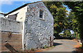
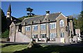
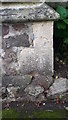
Old building, Oxford Road, Link Top, Malvern
The building was made of Malvern granite then later (probably in the 19th century) a solid 9" brick wall was added.
Image: © Bob Embleton
Taken: 1 Sep 2011
0.02 miles
3

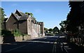
Link Terrace, Link Top, Malvern
Small enclosures on the Malvern Link Common, evolving into a residential area.
Viewed from near Lygon Bank.
Image: © Bob Embleton
Taken: 1 Sep 2011
0.03 miles
4
Trinity Ward war memorial, Link Top, Malvern
Located by the Worcester Road near the complex road junction with Newtown Road, Hornyold road and Trinity Road.
The plaque was on the "Link Top Memorial Shelter" opened on Thursday 3rd May 1951 at 3:30pm by "a north Malvern mother who lost two sons in the last [i.e. 2nd world] war."
The shelter was demolished when the new bus stop and shelter were constructed nearby.
The plaque, dated March 1951, reads:
"To the memory of those from
Trinity Ward
who made the supreme sacrifice
1914 - 1918
1938 - 1945"
Image]
Image: © Bob Embleton
Taken: 2 Sep 2011
0.03 miles
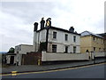
6
Holy Trinity Hall, Link Top, Malvern.
On the Worcester Road close to the junction of Hornyold Road.
Above and to the left is the spire of Holy Trinity Church.
North Hill looms behind.
Image: © Bob Embleton
Taken: 23 May 2009
0.03 miles
7
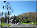
Link Top traffic lights and Holy Trinity Hall.
The awkward multiple junction of 5 minor roads to the main A449 Ross to Worcester road was improved in the 20th century.
Various roads were blocked off and junctions reorganised in the 1970s (with an estimated cost of £97,000).
Later the lights were added to give traffic joining the main A449 a chance during busy times of day.
Image: © Bob Embleton
Taken: 23 May 2009
0.03 miles
9
Malvern Link top - the traffic lights
The top of the major climb from the valley of the Severn, with still some further climbing into Great Malvern.
Image: © Peter Whatley
Taken: 2 Jun 2008
0.03 miles
10
Cut Mark Holy Trinity Church, Malvern
These marks were used by Ordnance Survey for mapping purposes.
Image: © V1ncenze
Taken: 30 Sep 2019
0.03 miles