IMAGES TAKEN NEAR TO
Field Fare Close, MALVERN, WR14 1UW
Introduction
This page details the photographs taken nearby to Field Fare Close, WR14 1UW by members of the Geograph project.
The Geograph project started in 2005 with the aim of publishing, organising and preserving representative images for every square kilometre of Great Britain, Ireland and the Isle of Man.

There are currently over 7.5m images from over14,400 individuals and you can help contribute to the project by visiting https://www.geograph.org.uk
Image Map
Images are licensed for reuse under creativecommons.org/licenses/by-sa/2.0
Notes
- Clicking on the map will re-center to the selected point.
- The higher the marker number, the further away the image location is from the centre of the postcode.
Image Listing (10 Images Found)
Images are licensed for reuse under creativecommons.org/licenses/by-sa/2.0
Image
Details
Distance
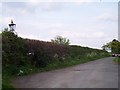
1

End of the Road
The end of the public road in Malvern Link as Hospital Road encounters Fieldfare Close.
Image: © Peter Whatley
Taken: 2 Jun 2008
0.03 miles
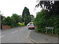
2
Gas Lamps in Hospital Road, Malvern
The TB Isolation Hospital was once here. Parts of Malvern still enjoy the beautiful light green glow of gas illumination.
Image: © Bob Embleton
Taken: 30 Apr 2005
0.04 miles
5
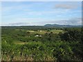
Malvern and the Malvern Hills from Bringsty Common
Image: © Martin Wynne
Taken: 3 Jul 2017
0.13 miles
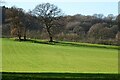
6
Arable land in the shadow of the Malvern Hills
View west from Halfkey Road towards Rough Hill.
Image: © Jonathan Billinger
Taken: 29 Sep 2015
0.19 miles
7
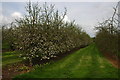
Apple orchard near Cowleigh
The Worcestershire Way passes through these apple orchards near Cowleigh.
Image: © Philip Halling
Taken: 5 May 2008
0.21 miles
8
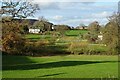
Farmland at Halfkey
Farmland and houses at Halfkey.
Image: © Philip Halling
Taken: 12 Dec 2020
0.21 miles
9
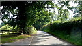
Halfkey Road
Country lane less than half a gridsquare from the northern limits of the Malvern conurbation.
Image: © Jonathan Billinger
Taken: 29 Sep 2015
0.23 miles
10
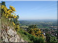
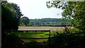
Fields and orchards North of Malvern
Just to the north of Malvern, the open countryside consists of farm land and orchards. The Worcester Way crosses the light green field just above the broom growing out of the granite of North Hill in the foreground.
Image: © Trevor Rickard
Taken: 3 Jun 2006
0.24 miles