IMAGES TAKEN NEAR TO
Worcester Road, MALVERN, WR14 1SP
Introduction
This page details the photographs taken nearby to Worcester Road, WR14 1SP by members of the Geograph project.
The Geograph project started in 2005 with the aim of publishing, organising and preserving representative images for every square kilometre of Great Britain, Ireland and the Isle of Man.

There are currently over 7.5m images from over14,400 individuals and you can help contribute to the project by visiting https://www.geograph.org.uk
Image Map (Loading...)


Getting Data...Please wait
Leaflet Map data © OpenStreetMap
Images are licensed for reuse under creativecommons.org/licenses/by-sa/2.0
Notes
- Clicking on the map will re-center to the selected point.
- The higher the marker number, the further away the image location is from the centre of the postcode.
Image Listing (254 Images Found)
Images are licensed for reuse under creativecommons.org/licenses/by-sa/2.0
Image
Details
Distance
1
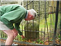
Old Milestone by the A449, Worcester Road, Malvern parish
Metal plate attached to stone post by the A449, in parish of Malvern (Malvern Hills District), Worcester Road, URC Churchyard, Malvern Link, behind church railings, on Southeast side of road. Worcester Cross iron plate, erected by the Worcester turnpike trust in the 19th century.
Inscription reads:-
TO
WORCESTER
CROSS
7
MILES
Carved benchmark on top.
Milestone Society National ID: WO_WOLB07
Image: © J Higgins
Taken: 1 Apr 2007
0.02 miles
2
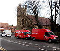
Two red HomeServe vans in Malvern Link
Viewed across the A449 Worcester Road. The motto on one van is We repair Britain's homes.
Image: © Jaggery
Taken: 29 Nov 2014
0.02 miles
3
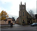
Malvern Link United Reformed Church
Viewed across the A449 Worcester Road.
Image: © Jaggery
Taken: 29 Nov 2014
0.02 miles
4
Worcester Road, Malvern Link
Viewed from outside the United Reformed Church.
Image
An old milestone sits behind the church railings.
Image
Image: © Bob Embleton
Taken: 29 Mar 2010
0.03 miles
5
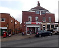
Malvern Link Post Office
Located in Worcester Road between two banks - Lloyds http://www.geograph.org.uk/photo/4261949 on the left and HSBC on the right.
Image: © Jaggery
Taken: 29 Nov 2014
0.03 miles
6
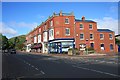
Block of shops in Malvern Link
On the main A449 Ross to Worcester Road between Hampden Road and Cromwell Road.
Viewed looking up towards Link Top and Great Malvern.
The block consists of buildings of varying architectures, but with a common roof decoration
(presumably added later by the single owner of the whole block).
The corner bears two carved stones: the top one bearing the date "1896" and the other bearing two initials "E" and "D" overlaid.
Image
Image
Image: © Bob Embleton
Taken: 28 May 2009
0.03 miles
7
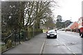
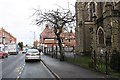
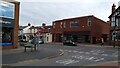
Worcester Road, Malvern Link
Viewed from outside the United Reformed Church.
Image
Behind the church railings there is an old milestone.
Image
The triangular building ahead is the modern Fire Station.
Image: © Bob Embleton
Taken: 29 Mar 2010
0.03 miles
8
Lloyds Bank, Malvern Link
The Worcester Road Malvern branch of Lloyds Bank, viewed in late November 2014,
used to be a branch of Lloyds TSB, rebranded in September 2013.
Image: © Jaggery
Taken: 29 Nov 2014
0.04 miles
9
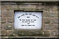
Foundation stone, United Reformed Church
Inscribed :-
"This stone was laid June 18th 1903
To the glory of God
For peace on earth and good will toward men"
Image
Image: © Bob Embleton
Taken: 29 Mar 2010
0.04 miles
10
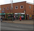
Another closed shop in Malvern Link
Francis Flooring has moved from the main road in Malvern Link to the nearby retail park. Handier for staff, suppliers and customers alike.
Image: © Peter Whatley
Taken: 19 Oct 2020
0.04 miles