IMAGES TAKEN NEAR TO
Belmont Road, MALVERN, WR14 1PL
Introduction
This page details the photographs taken nearby to Belmont Road, WR14 1PL by members of the Geograph project.
The Geograph project started in 2005 with the aim of publishing, organising and preserving representative images for every square kilometre of Great Britain, Ireland and the Isle of Man.

There are currently over 7.5m images from over14,400 individuals and you can help contribute to the project by visiting https://www.geograph.org.uk
Image Map (Loading...)


Getting Data...Please wait
Leaflet Map data © OpenStreetMap
Images are licensed for reuse under creativecommons.org/licenses/by-sa/2.0
Notes
- Clicking on the map will re-center to the selected point.
- The higher the marker number, the further away the image location is from the centre of the postcode.
Image Listing (49 Images Found)
Images are licensed for reuse under creativecommons.org/licenses/by-sa/2.0
Image
Details
Distance
1
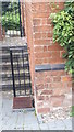
Ordnance Survey Cut Mark
Cut mark located on the wall outside number 18 Belmont Road, Malvern. These marks were used by Ordnance Survey for mapping purposes.
Image: © V1ncenze
Taken: 30 Sep 2019
0.03 miles
2
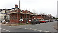
Building on the former coach depot
Houses are being constructed along Belmont Road on what was previously the depot for Malvernian Tours. The company ceased trading in December 2009 with the site being cleared during 2010.
Image: © Peter Whatley
Taken: 26 Sep 2013
0.06 miles
3
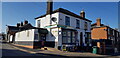
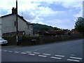
Charlies Convenience Store, Newtown Road
A small off-licence and grocery shop on the corner of Belmont Road.
Image: © Paul Collins
Taken: 27 Feb 2022
0.06 miles
4
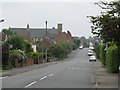
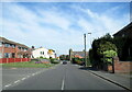
Malvern Link - Leigh Sinton Road
The last section of Leigh Sinton Road as it climbs away from the old DERA North Site to the Church of the Ascension crossroads.
Image: © Peter Whatley
Taken: 2 Jun 2008
0.07 miles
5
Newtown Road approaching the Church of the Ascension
Image: © Roy Hughes
Taken: 24 Apr 2021
0.07 miles
6
Former Jones' Coaches Site
Former Jones' coaches site which latterly became known as Malvernian Tours. The company has now ceased trading and the coaches sold off due to the recession.
Image: © James Pratt
Taken: 31 May 2010
0.07 miles
7
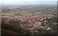
North Malvern
Viewed from the eastern side of North Hill.
In Victorian times this area grew to house the working class who served the large houses of Great Malvern. At the bottom right of the picture is the area known as Link Top. A large bare area towards then upper right of the picture was "North Site" - part of the radar research establishment. It has been demolished and is to become a controversial housing estate. Fears of traffic chaos, overflowing schools, flash flooding and perhaps some general nimby-ism have been rife in the local press.
Image: © Bob Embleton
Taken: 26 Jan 2008
0.08 miles
8
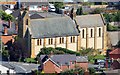
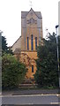
Church of the Ascension, North Malvern
The foundation stone was laid on the 19th december 1902 and the completed building was dedicated on the 3rd October 1903.
Image: © Bob Embleton
Taken: 13 Aug 2014
0.08 miles
10
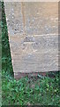
Ordnance Survey Cut Mark
Cut mark found on The Church of the Ascension, Malvern. These marks were used by Ordnance Survey for mapping purposes.
Image: © V1ncenze
Taken: 30 Sep 2019
0.08 miles