IMAGES TAKEN NEAR TO
Belmont Road, MALVERN, WR14 1PB
Introduction
This page details the photographs taken nearby to Belmont Road, WR14 1PB by members of the Geograph project.
The Geograph project started in 2005 with the aim of publishing, organising and preserving representative images for every square kilometre of Great Britain, Ireland and the Isle of Man.

There are currently over 7.5m images from over14,400 individuals and you can help contribute to the project by visiting https://www.geograph.org.uk
Image Map (Loading...)


Getting Data...Please wait
Leaflet Map data © OpenStreetMap
Images are licensed for reuse under creativecommons.org/licenses/by-sa/2.0
Notes
- Clicking on the map will re-center to the selected point.
- The higher the marker number, the further away the image location is from the centre of the postcode.
Image Listing (37 Images Found)
Images are licensed for reuse under creativecommons.org/licenses/by-sa/2.0
Image
Details
Distance
1
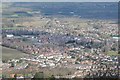
Malvern Link viewed from the Malvern Hills
Malvern Link and housing at the north end of Malvern viewed from the North Hill, the most northerly of the Malvern Hills.
Image: © Philip Halling
Taken: 21 Mar 2015
0.03 miles
2
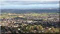
View over Upper Howsell
View over Upper Howsell from the Lady Howard De Walden Drive on the North Hill of the Malvern Hills. The city of Worcester can be seen to the right, in the sun, in the distance.
Image: © Philip Halling
Taken: 3 Feb 2024
0.11 miles
3
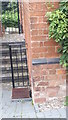
Ordnance Survey Cut Mark
Cut mark located on the wall outside number 18 Belmont Road, Malvern. These marks were used by Ordnance Survey for mapping purposes.
Image: © V1ncenze
Taken: 30 Sep 2019
0.12 miles
4
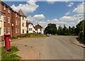
Postbox on Sayers Avenue, Malvern
On the left is a new housing development called Malvern Vale.
Image: © Mat Fascione
Taken: 12 Jun 2014
0.15 miles
5
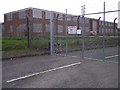
The old College of Electronics, RSRE North Site
Radar and electronics research is still a large employer in Malvern.
It once boasted this "College of Knowledge" where many of today's electronics experts were trained as apprentices.
Image: © Bob Embleton
Taken: 30 Apr 2005
0.16 miles
6
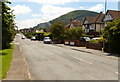
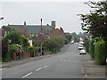
Leigh Sinton Road in Malvern
On the right is the 397 m (1,302 ft) North Hill, the second highest point of the Malvern Hills.
Image: © Mat Fascione
Taken: 12 Jun 2014
0.16 miles
7
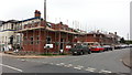
Building on the former coach depot
Houses are being constructed along Belmont Road on what was previously the depot for Malvernian Tours. The company ceased trading in December 2009 with the site being cleared during 2010.
Image: © Peter Whatley
Taken: 26 Sep 2013
0.16 miles
8
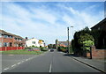
Newtown Road approaching the Church of the Ascension
Image: © Roy Hughes
Taken: 24 Apr 2021
0.16 miles
9
Malvern Link - Leigh Sinton Road
The last section of Leigh Sinton Road as it climbs away from the old DERA North Site to the Church of the Ascension crossroads.
Image: © Peter Whatley
Taken: 2 Jun 2008
0.16 miles
10
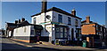
Charlies Convenience Store, Newtown Road
A small off-licence and grocery shop on the corner of Belmont Road.
Image: © Paul Collins
Taken: 27 Feb 2022
0.16 miles