IMAGES TAKEN NEAR TO
Newtown Road, MALVERN, WR14 1NZ
Introduction
This page details the photographs taken nearby to Newtown Road, WR14 1NZ by members of the Geograph project.
The Geograph project started in 2005 with the aim of publishing, organising and preserving representative images for every square kilometre of Great Britain, Ireland and the Isle of Man.

There are currently over 7.5m images from over14,400 individuals and you can help contribute to the project by visiting https://www.geograph.org.uk
Image Map
Images are licensed for reuse under creativecommons.org/licenses/by-sa/2.0
Notes
- Clicking on the map will re-center to the selected point.
- The higher the marker number, the further away the image location is from the centre of the postcode.
Image Listing (162 Images Found)
Images are licensed for reuse under creativecommons.org/licenses/by-sa/2.0
Image
Details
Distance
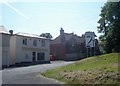
1
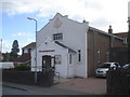
Salvation Army Worship & Community Centre
The Salvation Army chapel is situated on Newtown Road.
Image: © Trevor Rickard
Taken: 22 Jun 2008
0.04 miles
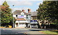
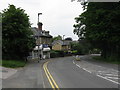
2
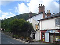
The Retired Soldier
Situated on Newtown Road, this pub is one of the smallest I've ever seen. Interestingly it is owned by The Royal Bank of Scotland, one of a set the bank purchased from Wolverhampton and Dudley Breweries. North Hill in the background.
Image: © Trevor Rickard
Taken: 22 Jun 2008
0.04 miles
3
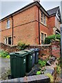
58 Newtown Rd, Malvern
Semi detached property near to central Malvern. This location is also the site of an Ordnance Survey bench mark.
Image: © V1ncenze
Taken: 23 Sep 2020
0.05 miles
4
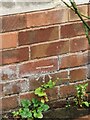
Ordnance Survey bench mark
This Bench Mark is located on the north facing wall of 58 Newtown Rd, Malvern. These marks were used by Ordnance Survey for mapping purposes.
Image: © V1ncenze
Taken: 23 Sep 2020
0.05 miles
6
Kwai Chinese takeaway
Looking eastwards across Newtown Road to one of the very best Chinese takeaways in the area.
Image: © Trevor Rickard
Taken: 8 Jun 2008
0.05 miles
7
Everley Stores, Link Top, Malvern
Located with a group of shops near the junction of the Newtown Road with Worcester Road and where the latter starts the descent to the Malvern Link shopping area.
A typical village store/corner shop selling everything one needs.
Before the changes in the Sunday trading laws this shop appeared to be the only place one could by a pint of milk after a Sunday spent driving home from holiday.
Image: © Bob Embleton
Taken: 1 Sep 2011
0.05 miles
8
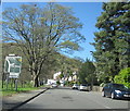
Worcester Road Malvern Link Approaching Turn For Leigh Sinton
Image: © Roy Hughes
Taken: 20 Apr 2016
0.06 miles
9
Corner shop
The sweet shop on the corner near Malvern Link top.
Image: © Peter Whatley
Taken: 2 Jun 2008
0.06 miles
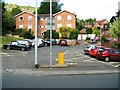
10
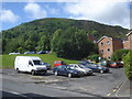
Car parks off Newtown Road
View south-west from Newtown Road to a couple of small car parks which service local shops and provide parking for blocks of flats. The imposing North Hill rises sharply behind.
Image: © Trevor Rickard
Taken: 22 Jun 2008
0.06 miles