IMAGES TAKEN NEAR TO
Kinnersley Road, MALVERN, WR14 1JZ
Introduction
This page details the photographs taken nearby to Kinnersley Road, WR14 1JZ by members of the Geograph project.
The Geograph project started in 2005 with the aim of publishing, organising and preserving representative images for every square kilometre of Great Britain, Ireland and the Isle of Man.

There are currently over 7.5m images from over14,400 individuals and you can help contribute to the project by visiting https://www.geograph.org.uk
Image Map (Loading...)


Getting Data...Please wait
Leaflet Map data © OpenStreetMap
Images are licensed for reuse under creativecommons.org/licenses/by-sa/2.0
Notes
- Clicking on the map will re-center to the selected point.
- The higher the marker number, the further away the image location is from the centre of the postcode.
Image Listing (8 Images Found)
Images are licensed for reuse under creativecommons.org/licenses/by-sa/2.0
Image
Details
Distance
1
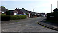
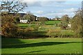
Kinnersley Road, Upper Howsell
Bungalows at the northern edge of the Malvern conurbation.
Image: © Jonathan Billinger
Taken: 29 Sep 2015
0.03 miles
2
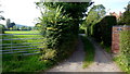
Track and footpath
A short track and public path north of Halfkey Road.
Image: © Jonathan Billinger
Taken: 29 Sep 2015
0.06 miles
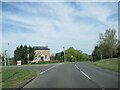
3
Leigh Sinton Road, Malvern
Heading out of Malvern past the last few houses on the northern edge of town.
Image: © Des Blenkinsopp
Taken: 30 Oct 2022
0.07 miles
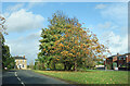
5
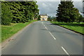
Leigh Sinton Road
Leigh Sinton Road as emerges from the northern edge of Malvern.
Image: © Philip Halling
Taken: 2 Aug 2009
0.08 miles
6
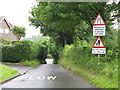
Malvern Link - Grit Lane
Surprisingly, this is the direct route north from a large housing estate. A survivor from the days when this was the road from Leigh Sinton, passing Grit Farm.
Image: © Peter Whatley
Taken: 3 Jun 2008
0.15 miles
8
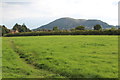
Farmland at Halfkey
Farmland and houses at Halfkey.
Image: © Philip Halling
Taken: 12 Dec 2020
0.24 miles