IMAGES TAKEN NEAR TO
Hollybush Close, MALVERN, WR14 1FN
Introduction
This page details the photographs taken nearby to Hollybush Close, WR14 1FN by members of the Geograph project.
The Geograph project started in 2005 with the aim of publishing, organising and preserving representative images for every square kilometre of Great Britain, Ireland and the Isle of Man.

There are currently over 7.5m images from over14,400 individuals and you can help contribute to the project by visiting https://www.geograph.org.uk
Image Map (Loading...)


Getting Data...Please wait
Leaflet Map data © OpenStreetMap
Images are licensed for reuse under creativecommons.org/licenses/by-sa/2.0
Notes
- Clicking on the map will re-center to the selected point.
- The higher the marker number, the further away the image location is from the centre of the postcode.
Image Listing (11 Images Found)
Images are licensed for reuse under creativecommons.org/licenses/by-sa/2.0
Image
Details
Distance
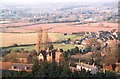
1
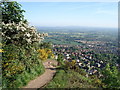
North side of Malvern
Taken from path leading up North Hill, the north boundary of Malvern town can be seen. The building site on the edge of town is North Site (the reverse view of an existing geograph), which was once part of the Royal Signals and Radar Establishment.
Image: © Trevor Rickard
Taken: 3 Jun 2006
0.09 miles
2
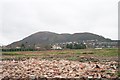
North Site - Demolished
The smaller of two war time, then post war radar research establishment sites.
From RRDE to RRE, RSRE, DRA then DERA. now to be a housing estate amid fears from local residents that the road infrastructure will not cope. An interesting view of the northern most peaks of the Malvern Hills. The somewhat mis-named North Hill on the left with End Hill on the right and the peak of Table hill visible in the middle.
Image: © Bob Embleton
Taken: 10 Dec 2006
0.14 miles
3
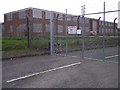
The old College of Electronics, RSRE North Site
Radar and electronics research is still a large employer in Malvern.
It once boasted this "College of Knowledge" where many of today's electronics experts were trained as apprentices.
Image: © Bob Embleton
Taken: 30 Apr 2005
0.17 miles
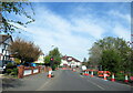
4
Housing on Sayers Ave
Modern housing built in the last ten years on Sayers Ave on the northern suburbs of Malvern.
Image: © Philip Halling
Taken: 12 Dec 2020
0.20 miles
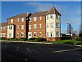
5
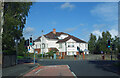
Northview Court
Apartments on Leigh Sinton Road.
Image: © Des Blenkinsopp
Taken: 30 Oct 2022
0.20 miles
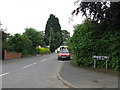
6
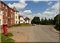
Postbox on Sayers Avenue, Malvern
On the left is a new housing development called Malvern Vale.
Image: © Mat Fascione
Taken: 12 Jun 2014
0.21 miles
8
Farmland to the northwest of Great Malvern
Image: © D Williams
Taken: 29 Apr 2003
0.21 miles
10
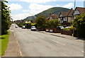
Leigh Sinton Road in Malvern
On the right is the 397 m (1,302 ft) North Hill, the second highest point of the Malvern Hills.
Image: © Mat Fascione
Taken: 12 Jun 2014
0.23 miles