IMAGES TAKEN NEAR TO
Uplands Drive, MALVERN, WR14 1FE
Introduction
This page details the photographs taken nearby to Uplands Drive, WR14 1FE by members of the Geograph project.
The Geograph project started in 2005 with the aim of publishing, organising and preserving representative images for every square kilometre of Great Britain, Ireland and the Isle of Man.

There are currently over 7.5m images from over14,400 individuals and you can help contribute to the project by visiting https://www.geograph.org.uk
Image Map (Loading...)


Getting Data...Please wait
Leaflet Map data © OpenStreetMap
Images are licensed for reuse under creativecommons.org/licenses/by-sa/2.0
Notes
- Clicking on the map will re-center to the selected point.
- The higher the marker number, the further away the image location is from the centre of the postcode.
Image Listing (54 Images Found)
Images are licensed for reuse under creativecommons.org/licenses/by-sa/2.0
Image
Details
Distance
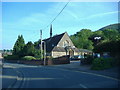
1
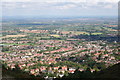
North Malvern
Taken from End Hill. North Malvern developed during the late 19th century and early 20th century to house those who worked for the richer houses of Great Malvern. Here we are looking along a straight stretch of the railway line to Worcester which can be seen in the distance.
Image: © Bob Embleton
Taken: 24 Sep 2006
0.04 miles
2
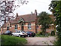
The Rural Hospital
Malvern's first hospital opened in 1868. Paid for by public subscription after a horrific accident destroyed a family transporting vitriol to Malvern Wells where they use this to make bottled fizzy water.
Image: © Bob Embleton
Taken: 16 Apr 2005
0.04 miles
3
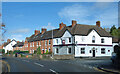
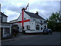
Prince of Wales, Newtown Road
On the corner of Newtown Road and Hospital Bank.
Image: © Des Blenkinsopp
Taken: 30 Oct 2022
0.08 miles
4
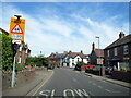
Newton Road near the Prince of Wales Feathers public house
Image: © Roy Hughes
Taken: 24 Apr 2021
0.09 miles
5
Site of Malvern's first hospital
Site of Malvern's first hospital on Hospital Bank Image
Image: © Philip Halling
Taken: 25 Oct 2020
0.10 miles
6
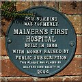
Plaque to Malvern's first hospital
Plaque on a wall at the site of Malvern's first hospital.
Image: © Philip Halling
Taken: 25 Oct 2020
0.10 miles
7
Nursery Road at its junction with Newtown Road
North Hill and its disused quarry form a backdrop to the area.
Image: © Peter Whatley
Taken: 26 Sep 2013
0.10 miles
10
The Old Malvern Hospital, North Malvern
The old hospital building is partly obscured by the tall tree. Built in the 1860s by a massive public subscription drive following a horrific accident where a family were destroyed by vitriol. In the early 1900s Dyson Perrins (of Worcester Sauce fame) built a new hospital in Great Malvern. Now there is a real chance (fingers crossed) that we shall get a new hospital in Malvern Link.
Image: © Bob Embleton
Taken: 26 Jan 2008
0.11 miles